Ներողություն ենք խնդրում կայքի մեքենայական թարգմանության հնարավոր սխալների համար
2.3. Էկոհամակարգերի տարածվածությունը (բուսականության տեսակներ))
Թարմացված բուսածածկույթի քարտեզի ստեղծում – Ալլա Ալեքսանյանը (ՀՀ ԳԱԱ Ա. Թախտաջյանի անվան բուսաբանության ինստիտուտ)
Բուսածածկույթի քարտեզի թվայնացում – Վարդան Ասատրյանը (ՀՀ ԳԱԱ կենդանաբանության և հիդրոէկոլոգիայի գիտական կենտրոն)
ԳԻՍ մոդելավորում, վերլուծություն և արդյունքների ներկայացում – Էդուարդ Կազակով (NextGIS OÜ, Էստոնիա)
Արդյունքների վերլուծություն և ներկայացում – Ելենա Բուկվարևա (ԲԿԿ-Հայաստան)
2.3.A. Էկոհամակարգի տարածքը ազգային և մարզային մակարդակներում
Բուսականության տեսակները ամենահստակ արտացոլում են ցամաքային էկոհամակարգերի բնութագրերը, քանի որ բուսականությունը արտացոլում է բնակավայրի բոլոր հիմնական պայմանները (կլիմա, հող, տոպոգրաֆիա), կազմավորում է էկոհամակարգերի սննդային հիմքը և մեծապես որոշում է թե դրանց գործառույթը, թե տեսակային բազմազանությունը։ Էկոհամակարգային տեսակների տարածվածության գնահատումը կատարվել է նախագծի փորձագետներ Ալլա Ալեքսանյանն ու Վարդան Ասատրյանն (Նկ. 23A-1a) ստեղծած բուսականության քարտեզի հիման վրա։ Քարտեզը կազմվել է Բարսեղյան (2007) և այլ նյութերի հիման վրա։
Բուսական գոտիների ներկայիս բնական տարածքը սահմանվում է որպես տվյալ բուսականության տեսակի հնարավոր տարածք՝ հանած հացահատիկային ցանքատարածքներն ու կառուցապատված տարածքները՝ հիմնվելով ESRI-ի 2023 թ. հողածածկույթի տվյալների վրա (Նկ. 23A-1b): Առկա անտառների բաշխումը նույնպես ստացվում է ESRI-ի հողածածկույթի տվյալներից (Նկ. 23A-1c): Այս նախնական ուսումնասիրության փուլում բոլոր անտառները դիտարկվում են որպես մեկ միատեսակ, անկախ այն բուսածածկության գոտուց, որտեղ դրանք գտնվում են: Ապագայում, երբ կազմվի մանրամասն երկրային էկոհամակարգերի քարտեզ, անտառները նույնպես պետք է դասակարգվեն ըստ տեսակների: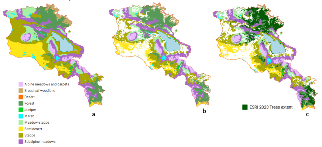
Նկ. 23A-1. Բուսածածկույթի քարտեզներ: ա) բուսածածկույթի տեսակների հնարավոր տարածում; բ) բուսածածկույթի գոտիների ներկայիս բնական տարածք; գ) էկոհամակարգերի տեսակներ, ներառյալ ներկայիս ծառածածկույթը Մանրամասն քարտեզի համար տեսեք նախագծի Web-GIS-ը, «Էկոհամակարգի տարածք/Բուսածածկույթ/Բուսածածկույթի քարտեզ 2025» բաժինները։
Ըստ ESRI տվյալների՝ մարդու կողմից առավել վերափոխված բուսածածկույթի գոտին կիսաանապատն է, որտեղ պահպանվել է բնական տարածքների 56%-ը։ Այնուհետև գալիս են ճահճուտներն ու ստեփաները՝ համապատասխանաբար 70% և 76% բնական տարածքներով։ Ծառածածկույթը զբաղեցնում է անտառային գոտու ավելի քան 40%-ը և լայնատերև անտառային գոտու ավելի քան 20%-ը։ Նշանակալի անտառային հատվածներ կան նաև ենթալպյան արոտավայրերում, արոտավայր-ստեփպե և ստեփպե գոտիներում։ Մնացած գոտիներում ESRI-ի կողմից նույնականացված ծառածածկույթը զբաղեցնում է շատ փոքր տարածք՝ 0–4 կմ²։ Բոգոտների գոտում ջրային մարմինները զբաղեցնում են զգալի տարածք (Սևան լիճը բացառված է վերլուծությունից) (Աղյուսակ 23A-1; Նկ. 23A-2)։
Աղյուսակ 23A-1. Բուսածածկույթի գոտիներում հողածածկույթի դասերի ընթացիկ մակերեսը, կմ2
| Ցողուն–երկրներ | Ծառ ծածկ | Բարե Գր-դ | Ձյուն/ Սառույց | Ջրհեղեղ. բուսակեր | Ջուր | Մշակաբույսեր | Կառուցված | Ընդամենը | Բնականի բաժին դասեր, % | |
| Ալպին | 1625.72 | 0.63 | 10.21 | 11.70 | 0.03 | 1.93 | 3.32 | 0.80 | 1654.34 | 99.75 |
| Սուբալպինային | 4287.98 | 256.92 | 5.28 | 0.26 | 0.09 | 2.85 | 85.56 | 25.20 | 4664.14 | 97.63 |
| Մարգագետնատափաստան | 2587.14 | 77.83 | 0.22 | 0.04 | 0.76 | 6.66 | 460.94 | 93.06 | 3226.64 | 82.83 |
| Տափաստանային | 5229.35 | 95.86 | 3.24 | 0.00 | 0.03 | 4.89 | 1317.52 | 403.45 | 7054.33 | 75.60 |
| Անտառային գոտի | 2892.93 | 2431.91 | 3.91 | 0.00 | 0.60 | 30.37 | 155.70 | 199.61 | 5715.04 | 93.78 |
| Լայնատերև փայտ | 695.02 | 269.12 | 2.64 | 0.00 | 0.01 | 7.29 | 125.86 | 83.92 | 1183.86 | 82.28 |
| Գիհի | 129.59 | 4.20 | 0.00 | 0.00 | 0.16 | 0.08 | 0.87 | 0.12 | 135.02 | 99.27 |
| Կիսաանապատ | 2459.00 | 3.44 | 8.62 | 0.00 | 2.90 | 29.21 | 1212.83 | 716.50 | 4432.49 | 56.47 |
| Անապատ | 6.64 | 0.00 | 0.21 | 0.00 | 0.00 | 0.00 | 0.52 | 0.28 | 7.65 | 89.58 |
| Մարշ | 229.59 | 0.84 | 1.00 | 0.00 | 3.89 | 45.54 | 85.81 | 32.63 | 399.30 | 70.34 |
| Ընդհանուրը Արմենիայում | 20142.95 | 3140.75 | 35.35 | 12.00 | 8.46 | 128.82 | 3448.92 | 1555.56 | 28472.82 | 82.42 |
1. Բուսականության գոտիների տարածվածություն և ներկայիս բուսականություն
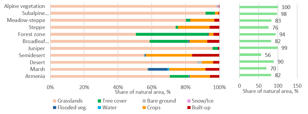
Ըստ ESRI տվյալների՝ մարդու կողմից առավել վերափոխված բուսածածկույթային գոտին կիսաանապատն է, որտեղ բնական տարածքների 57%-ն է պահպանվել։ Հաջորդում են ճահճակներ և ստեփա՝ համապատասխանաբար 71% և 76% բնական տարածքներով։ Ծառածածկույթը անտառային գոտում կազմում է ավելի քան 40%, իսկ լայնատերև անտառային գոտում՝ ավելի քան 20%։ Նշանակալի անտառային կղզիներ կան նաև ենթալպյան արոտներում, արոտ-ստեփպեներում և ստեփպե գոտիներում։ Մնացած գոտիներում ESRI-ի կողմից նույնականացված ծառածածկույթը զբաղեցնում է շատ փոքր տարածք՝ 0-ից մինչև 4 կմ²։ Բոգուտի գոտում ջրային մարմինները զբաղեցնում են զգալի տարածք (Սևան լիճը բացառված է վերլուծությունից)։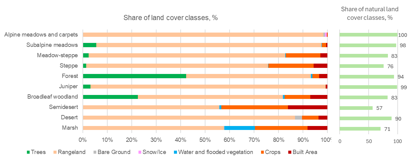 Նկ. 4. Երկրի ծածկույթի դասերի բաժինը բուսական գոտիներում, %
Աղյուսակ 1. Բուսածածկության գոտիներում հողածածկույթի դասերի ընթացիկ մակերեսը, կմ2
| Ծառեր | Փարթիք | Մերկ գետնին | Ձյուն/Սառույց | Ջուր/ Ջրհեղեղված բանջարեղեն | Մշակաբույսեր | Շինության մակերես | Տվյալներ չկան ամպեր | Ընդամենը | Բնական LC դասերի բաժին, % | |
| Ալպյան բուսածածկույթ | 0.61 | 1632.30 | 10.32 | 11.65 | 1.97 | 3.46 | 0.78 | 2.83 | 1663.92 | 100 |
| Ենթալպյան մարգագետիններ | 254.58 | 4266.55 | 5.53 | 0.27 | 3.03 | 84.53 | 24.84 | 19.79 | 4659.12 | 98 |
| Մարգագետնատափաստան | 76.39 | 2549.78 | 0.22 | 0.04 | 7.25 | 451.65 | 91.45 | 22.66 | 3199.42 | 83 |
| Տափաստանային | 94.59 | 5217.84 | 3.25 | 0.00 | 5.05 | 1302.02 | 399.16 | 27.97 | 7049.88 | 76 |
| Անտառ | 2397.98 | 2888.01 | 3.92 | 0.00 | 30.51 | 154.96 | 197.66 | 21.76 | 5694.79 | 94 |
| Գիհի | 4.23 | 130.60 | 0.12 | 0.00 | 0.09 | 0.17 | 0.89 | 0.05 | 136.15 | 99 |
| Լայնատերև անտառային հողատարածք | 263.67 | 691.61 | 2.65 | 0.00 | 7.28 | 123.48 | 82.12 | 27.23 | 1198.03 | 83 |
| Կիսաանապատ | 3.46 | 2462.38 | 9.03 | 0.00 | 33.04 | 1211.12 | 715.19 | 50.39 | 4484.59 | 57 |
| Անապատ | 0.00 | 6.67 | 0.22 | 0.00 | 0.00 | 0.52 | 0.28 | 0.00 | 7.69 | 90 |
| Մարշ | 0.82 | 228.14 | 1.01 | 0.00 | 49.54 | 85.19 | 32.46 | 3.09 | 400.25 | 71 |
| Հայաստան | 3096.34 | 20073.85 | 36.27 | 11.96 | 137.74 | 3417.09 | 1544.83 | 175.76 | 28493.85 | 83 |
Նկ. 23A-2. Երկրի ծածկույթի դասերի բաժինը բուսական գոտիներում, %
Բոլոր ծառածածկ տարածքները որպես անտառ հաշվի առնելով՝ ամենատարածված բնական տարածքները գտնվում են ստեփեի և ենթալպյան գոտիներում (համապատասխանաբար ավելի քան 5 000 և 4 000 կմ²), որին հաջորդում են անտառային գոտու անտառներն ու խոտածածկ տարածքները՝ յուրաքանչյուրը մոտ 3 000 կմ²։ Ամենափոքր գոտիներն են ճահճուտներն ու եղինջի անտառները (270 և 130 կմ², համապատասխանաբար), ինչպես նաև չափազանց փոքր անապատային գոտին, որը բաղկացած է մեկ միակ հատվածից՝ ընդամենը 7 կմ² (Նկ. 23A-3):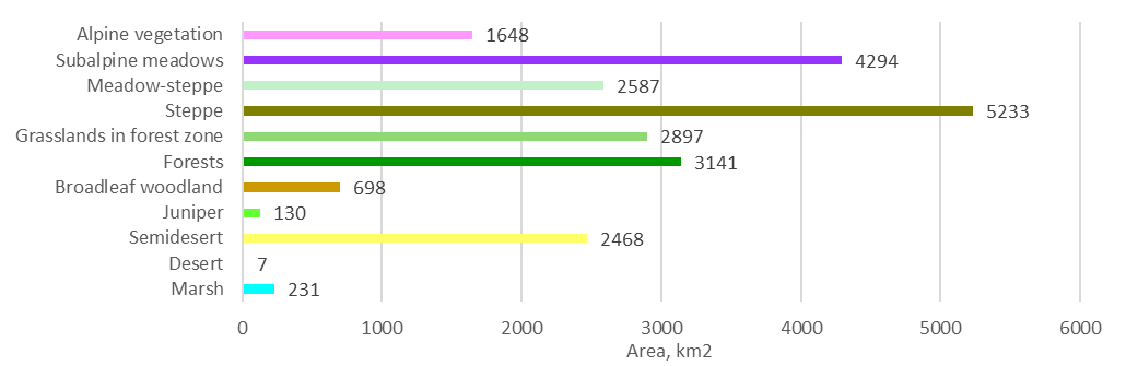 Նկար 23A-3. Բնական էկոհամակարգերի տեսակների տարածք, կմ2
Էկոհամակարգի տարածքը (այսինքն՝ այն տարածքը, որը զբաղեցված չէ մշակաբույսերի հողերով կամ կառուցապատված տարածքներով) առավել մեծ է Սյունիքի մարզում և առավել փոքր՝ Արմավիրի մարզում (Աղյուսակ 23A-2; Նկար 23A-4): Լորի, Սյունիք և Տավուշ մարզերի անտառային գոտում անտառներն ու խոտածածկ տարածքները զբաղեցնում են առավել մեծ տարածքներ: Ալպյան և ենթալպյան էկոհամակարգերը առավել տարածված են Սյունիքի և Գեղարքունիքի մարզերում։ Ստեփան և խոտաստեփան զբաղեցնում են զգալի տարածքներ բոլոր մարզերում՝ բացի Արմավիրից և Տավուշից, առավել մեծ տարածքով Գեղարքունիքում և Շիրակում։ Բնական կիսաանապատի ամենամեծ տարածքները պահպանվել են Արագածոտնի, Արմավիրի և Արարատի մարզերում։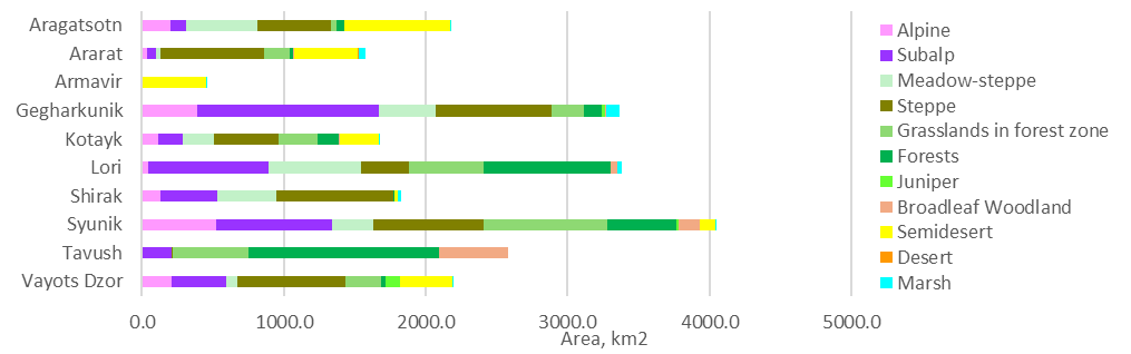 Նկար 23A-4. Բնական բուսածածկույթի տեսակների տարածքը մարզերում, 2023 թ.
Աղյուսակ 23A-2. Բնական էկոհամակարգերի, անտրոպոգեն հողածածկույթի դասերի և ջրային մարմինների (բացառությամբ Սևան լճի) տարածքը մարզերով, 2023 թվականին
| Ջուր | Մշակաբույսեր | Կառուցված | Ալպին | Սուբալպ | Մարգագետնատափաստան | Տափաստանային | Անտառային գոտու խոտածածկ տարածքներ | Արտակարգ վիճակ | Գիհի | Լայնատերեւ անտառ | Կիսաանապատ | Անապատ | Մարշ | Ընդամենը | ||
| 2023 թվականի տարածք, քմ² | Արագածոտն | 3.4 | 443.4 | 140.3 | 204.5 | 107.1 | 502.7 | 517.5 | 42.9 | 48.9 | 0 | 0 | 746.6 | 0 | 5.3 | 2762.6 |
| Արարատ | 37.9 | 303.4 | 176.6 | 37.2 | 62.9 | 30.8 | 733.2 | 176.2 | 26.1 | 0 | 9.5 | 444.1 | 6.9 | 49.8 | 2094.6 | |
| Արմավիր | 6.7 | 609.6 | 183.2 | 0 | 0 | 0 | 0 | 0 | 0.4 | 0 | 0 | 448.8 | 0 | 6.9 | 1255.6 | |
| Գեղարքունիք | 28.2 | 407.2 | 192.9 | 389.9 | 1280.8 | 400.3 | 817.8 | 227 | 127.9 | 20.8 | 10.6 | 0 | 0 | 92.8 | 3996.2 | |
| Կոտայք | 2.6 | 267.5 | 183.8 | 113.9 | 175.9 | 221.7 | 451.6 | 272.6 | 155.1 | 0 | 1.7 | 278.8 | 0 | 8.2 | 2133.4 | |
| Լոռի | 4.7 | 307.2 | 151.5 | 45 | 847.9 | 649.5 | 337.3 | 526.4 | 899.2 | 0 | 41.8 | 0 | 0 | 31.3 | 3841.8 | |
| Շիրակ | 30.9 | 758 | 145.5 | 128.3 | 403.9 | 413.5 | 823.9 | 0 | 13.7 | 0 | 0 | 17.3 | 0 | 29 | 2764 | |
| Սյունիք | 15 | 228.7 | 72 | 524.3 | 813.1 | 291.1 | 781.4 | 871.8 | 487.4 | 12.6 | 145.7 | 110.2 | 0 | 6.5 | 4359.8 | |
| Տավուշ | 4.4 | 82.1 | 97.7 | 0.3 | 210.9 | 0 | 6.5 | 534 | 1343.7 | 0 | 483.5 | 0 | 0 | 0 | 2763.1 | |
| Վայոց ձոր | 2.3 | 32.9 | 44.9 | 210.7 | 385.1 | 77.7 | 763.3 | 246 | 37.9 | 96.3 | 4.6 | 364.7 | 0 | 0.8 | 2267.2 | |
| Ընդամենը | 136.1 | 3440 | 1388.4 | 1654.1 | 4287.6 | 2587.3 | 5232.5 | 2896.9 | 3140.3 | 129.7 | 697.4 | 2410.5 | 6.9 | 230.6 | 28238.3 |
2.3.B. Էկոհամակարգերի հազվադեպությունը Հայաստանում
Ներկայումս անապատային, կեռասենու և ճահճային գոտիները ունեն ամենափոքր բնական տարածքները (Հայաստանի տարածքի 11%-ից պակաս): լայնատերև անտառները նույնպես հազվադեպ են (21%): ամենատարածված են ստեփան և ենթալպյան արոտավայրերը (181% և 141%), որին հաջորդում են անտառները (111%): Այլ խոտածածկ տարածքները կազմում են Արմենիայի տարածքի 61%-ից մինչև 101%-ը և կարող են համարվել տարածված (Նկ. 23B-1, 23B-2):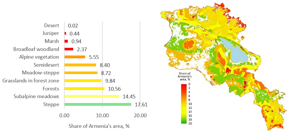
Նկ. 23B-1. Էկոհամակարգերի տեսակների դասակարգումը հազվադեպության ըստ (ա) և էկոհամակարգերի հազվադեպության քարտեզը (բ)
Հայաստանում էկոհամակարգային բազմազանության պահպանման համար մարզերի կարևորությունը գնահատելու նպատակով մենք օգտագործեցինք էկոհամակարգային տեսակների ազգային տարածքի այն մասի ցուցանիշը, որը պահպանվում է մարզերում, և այդ արժեքների մարզային գումարը (աղյուսակ 23B-1): Այս մոտեցումը կիրառվեց՝ ապահովելու համար, որ հազվագյուտ էկոհամակարգերի արժեքը չնվազի: Այս չափանիշի համաձայն՝ Արարատյան մարզն է ամենակարևորը Արմենիայի էկոհամակարգային բազմազանության պահպանման համար, քանի որ այն ընդգրկում է երկրի միակ անապատային տարածքը (100%). Սյունիքի մարզի բարձր արժեքը պայմանավորված է նրանով, որ այն ընդգրկում է էկոհամակարգերի բոլոր տեսակները։ Գեղարքունիքի մարզի ներդրումը մեծապես պայմանավորված է նրա տարածքում գտնվող ճահճակների բարձր մասնաբաժնով, իսկ Վայոց Ձորի մարզի ներդրումը՝ բարքենի անտառների բարձր մասնաբաժնով (Նկ. 23B-2):
Աղյուսակ 23B-1. Մարզերում պահպանվող ազգային տարածքի էկոհամակարգային տեսակների բաժինը, %.
| Լեռնային բուսականություն | Ենթալպյան մարգագետիններ | Մարգագետնատափաստան | Տափաստանային | Անտառային գոտու խոտածածկ տարածքներ | Արտակարգ վիճակ | Գիհի | Լայնատերեւ անտառ | Կիսաանապատ | Անապատ | Մարշ | Ընդամենը | |
| Արագածոտն | 12.36 | 2.50 | 19.43 | 9.89 | 1.48 | 1.56 | 0.00 | 0.00 | 30.97 | 0.00 | 2.30 | 80.49 |
| Արարատ | 2.25 | 1.47 | 1.19 | 14.01 | 6.08 | 0.83 | 0.00 | 1.36 | 18.42 | 100.00 | 21.60 | 167.21 |
| Արմավիր | 0.00 | 0.00 | 0.00 | 0.00 | 0.00 | 0.01 | 0.00 | 0.00 | 18.62 | 0.00 | 2.99 | 21.62 |
| Գեղարքունիք | 23.57 | 29.87 | 15.47 | 15.63 | 7.84 | 4.07 | 16.04 | 1.52 | 0.00 | 0.00 | 40.24 | 154.25 |
| Կոտայք | 6.89 | 4.10 | 8.57 | 8.63 | 9.41 | 4.94 | 0.00 | 0.24 | 11.57 | 0.00 | 3.56 | 57.90 |
| Լոռի | 2.72 | 19.78 | 25.10 | 6.45 | 18.17 | 28.63 | 0.00 | 5.99 | 0.00 | 0.00 | 13.57 | 120.42 |
| Շիրակ | 7.76 | 9.42 | 15.98 | 15.75 | 0.00 | 0.44 | 0.00 | 0.00 | 0.72 | 0.00 | 12.58 | 62.63 |
| Սյունիք | 31.70 | 18.96 | 11.25 | 14.93 | 30.09 | 15.52 | 9.71 | 20.89 | 4.57 | 0.00 | 2.82 | 160.46 |
| Տավուշ | 0.02 | 4.92 | 0.00 | 0.12 | 18.43 | 42.79 | 0.00 | 69.33 | 0.00 | 0.00 | 0.00 | 135.61 |
| Վայոց ձոր | 12.74 | 8.98 | 3.00 | 14.59 | 8.49 | 1.21 | 74.25 | 0.66 | 15.13 | 0.00 | 0.35 | 139.39 |
| Ընդամենը | 100.00 | 100.00 | 100.00 | 100.00 | 100.00 | 100.00 | 100.00 | 100.00 | 100.00 | 100.00 | 100.00 |
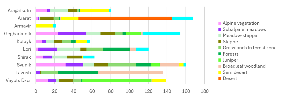
Նկ. 23B-2. Մարզերում պահպանվող ազգային տարածքի էկոհամակարգային տեսակների բաժինների (%%) գումարը։
2.3.C. Փոփոխություններ էկոհամակարգի տարածվածության չափը 2017-ից մինչև 2023 թվականը
Բուսածածկության տեսակների անցման մատրիցը ցույց է տալիս, թե ինչպես են բուսածածկության գոտիների տարածքները անցել հողածածկույթի դասերի (օրինակ՝ ստեփային բուսածածկությունը վերածվել է մշակվող հողերի, կառուցապատված տարածքների, մերկ հողի կամ ծառածածկույթի, և հակառակը): գոտուց գոտի բուսածածկության անցումները PV1-ում չեն գրանցվել, քանի որ գոտիների սահմանները չեն փոխվել: Աղյուսակ 23C-1-ը ներկայացնում է համախմբված տվյալներ՝ մերկ հողը և ձյուն/սառույցը ավելացվում են համապատասխան բուսածածկության գոտու բնական տարածքին, իսկ ջրի և ջրհեղեղված բուսածածկության տարածքները միավորվում են (ամբողջ մատրիցի համար տես Հավելված 3): Տվյալները բուսական գոտիների բնական տարածքներից դեպի անթրոպոգեն տարածքներ և ծառածածկույթ—և հակառակ ուղղությամբ—թույլ են տալիս մեզ լրացնել հաշվարկային աղյուսակի (Աղյուսակ 23C-2) «Տարածքի ավելացումներ» և «Տարածքի նվազեցումներ» տողերը։
Աղյուսակ 23C-1. 2017–2023 թթ. համախմբված բուսածածկույթի տեսակների անցման մատրիցա, կմ2
| Ալպյան բուսածածկույթ | Ենթալպյան մարգագետիններ | Մարգագետնատափաստան | Տափաստանային | Գրասլ. անտառային գոտում | Գիհի | Լայնատերեւ անտառ | Կիսաանապատ | Անապատ | Մարշ | Արտակարգ վիճակ | Ջուր և ջրհեղեղ։ բանջարեղեն։ | Մշակաբույսեր | Կառուցված | Ընդհանուր մակերեսը 2017 թվականին | Փոքրացում | |
| Ալպյան բանջարեղեն | 1642.9 | 0.0 | 0.0 | 0.0 | 0.0 | 0.0 | 0.0 | 0.0 | 0.0 | 0.0 | 0.4 | 0.2 | 2.3 | 0.1 | 1645.9 | 3.0 |
| Ենթալպյան մարգագետիններ | 0.0 | 4216.6 | 0.0 | 0.0 | 0.0 | 0.0 | 0.0 | 0.0 | 0.0 | 0.0 | 19.6 | 0.5 | 60.9 | 2.9 | 4300.5 | 83.8 |
| Մարգագետնատափաստան | 0.0 | 0.0 | 2552.1 | 0.0 | 0.0 | 0.0 | 0.0 | 0.0 | 0.0 | 0.0 | 10.9 | 2.3 | 270.0 | 6.2 | 2841.5 | 289.4 |
| Տափաստանային | 0.0 | 0.0 | 0.0 | 5039.5 | 0.0 | 0.0 | 0.0 | 0.0 | 0.0 | 0.0 | 11.3 | 1.0 | 370.2 | 21.3 | 5443.2 | 403.8 |
| Գրասլ. անտառային գոտում | 0.0 | 0.0 | 0.0 | 0.0 | 2628.1 | 0.0 | 0.0 | 0.0 | 0.0 | 0.0 | 143.6 | 1.4 | 54.9 | 22.2 | 2850.2 | 222.1 |
| Գիհի | 0.0 | 0.0 | 0.0 | 0.0 | 0.0 | 127.5 | 0.0 | 0.0 | 0.0 | 0.0 | 0.9 | 0.0 | 0.2 | 0.2 | 128.8 | 1.2 |
| Լայնատերեւ անտառ | 0.0 | 0.0 | 0.0 | 0.0 | 0.0 | 0.0 | 640.4 | 0.0 | 0.0 | 0.0 | 36.2 | 2.5 | 24.9 | 6.6 | 710.6 | 70.2 |
| Կիսաանապատ | 0.0 | 0.0 | 0.0 | 0.0 | 0.0 | 0.0 | 0.0 | 2274.9 | 0.0 | 0.0 | 1.1 | 4.4 | 142.5 | 55.8 | 2478.5 | 203.6 |
| Անապատ | 0.0 | 0.0 | 0.0 | 0.0 | 0.0 | 0.0 | 0.0 | 0.0 | 6.8 | 0.0 | 0.0 | 0.0 | 0.0 | 0.3 | 7.1 | 0.3 |
| Մարշ | 0.0 | 0.0 | 0.0 | 0.0 | 0.0 | 0.0 | 0.0 | 0.0 | 0.0 | 212.5 | 0.2 | 5.1 | 17.1 | 1.9 | 236.8 | 24.3 |
| Արտակարգ վիճակ | 3.2 | 62.5 | 11.4 | 22.7 | 238.5 | 2.0 | 18.8 | 3.3 | 0.0 | 0.4 | 2909.9 | 0.6 | 3.7 | 2.7 | 3279.8 | 369.9 |
| Ջուր/ջրհեղեղված բուսականություն | 0.2 | 0.4 | 1.2 | 0.8 | 1.8 | 0.0 | 0.6 | 4.2 | 0.0 | 5.3 | 0.5 | 110.9 | 9.2 | 2.4 | 137.5 | 26.6 |
| Մշակաբույսեր | 1.3 | 12.6 | 20.3 | 162.8 | 21.8 | 0.0 | 35.5 | 179.1 | 0.1 | 11.5 | 3.0 | 7.8 | 2478.5 | 97.2 | 3031.7 | 553.2 |
| Կառուցված | 0.1 | 1.4 | 2.4 | 6.8 | 6.6 | 0.2 | 2.3 | 6.0 | 0.0 | 0.8 | 3.3 | 0.5 | 13.7 | 1336.6 | 1380.7 | 44.1 |
| Ընդհանուր մակերեսը 2023 թվականին | 1647.6 | 4293.5 | 2587.4 | 5232.6 | 2896.8 | 129.7 | 697.7 | 2467.6 | 6.9 | 230.6 | 3140.7 | 137.1 | 3448.2 | 1556.3 | 28472.8 | 2295.46 |
| Ընդլայնում | 4.8 | 76.9 | 35.3 | 193.1 | 268.8 | 2.2 | 57.2 | 192.7 | 0.1 | 18.0 | 230.9 | 26.2 | 969.7 | 219.7 | 2295.5 |
Աղյուսակ 2.3.С-2. Բուսածածկույթի տեսակների տարածքի հաշվառման աղյուսակ՝ 2017 և 2023 թվականների համար, կմ²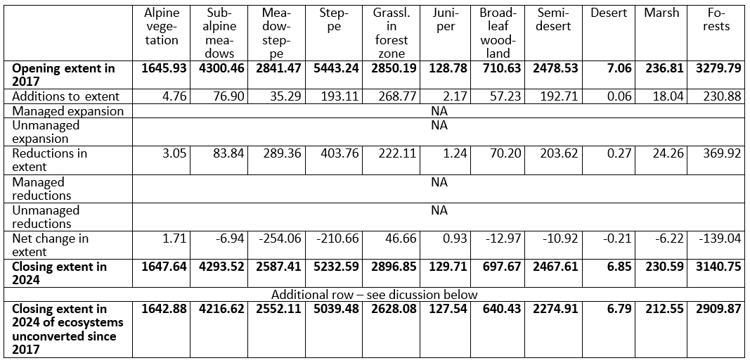
Ամենամեծ փոխակերպման տարածքները ներկայացվում են տարբեր արոտավայրերի տեսակների հողագործական դաշտերի վերածմամբ՝ 370 կմ² ստեպեր, 270 կմ² մարգագետնային ստեպեր, 144 կմ² կիսաանապատներ և 61 կմ² ենթալպյան մարգագետիններ են վերածվել հողագործական դաշտերի։ Հողագործական տարածքների ընդհանուր աճը կազմել է 970 կմ² (Աղյուսակ 23C-1; Նկար 23C-1): Հակադարձ գործընթացը՝ հողագործական հողերի վերածումը արոտավայրերի, թույլ էր և չէր կարող փոխհատուցել դրանց կորուստը: Առանձնահատուկ են կիսաանապատներն ու անտառային գոտիները, որտեղ հողատվական հողամասերից հակադարձ անցումը գերազանցել է նոր գյուղատնտեսական ընդլայնումը։ Շրջանառվող տարածքների պաշտոնական հարաբերակցության հիման վրա՝ այս գոտիներում գյուղատնտեսական զարգացման ինտենսիվությունը նվազել է։ Հակառակ միտումը նկատվում է խոտածածկ-ստեփերում և ենթալպյան խոտավայրերում, որտեղ հակադարձ անցումները չափազանց փոքր են, ինչը վկայում է գյուղատնտեսական ընդլայնման ինտենսիվության աճի մասին (Նկ. 23C-2)։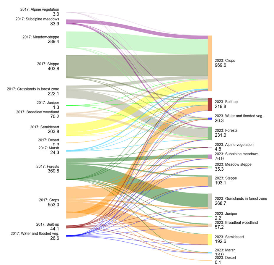 Նկար 23C-1. Բուսածածկույթի գոտիների և հողածածկույթի դասերի միջև անցումները։ Ինքնանցումները (դասերի անփոփոխություն) չեն ցուցադրվում։ Նկարագրության ընդհանուր կորուստներն ու շահույթները մի փոքր տարբերվում են 23С-1 աղյուսակում նշվածներից, քանի որ դրանք SankeyMATIC-ը հաշվել է ընդհանուրների համար կիրառվող այլ կլորացման մոտեցմամբ։
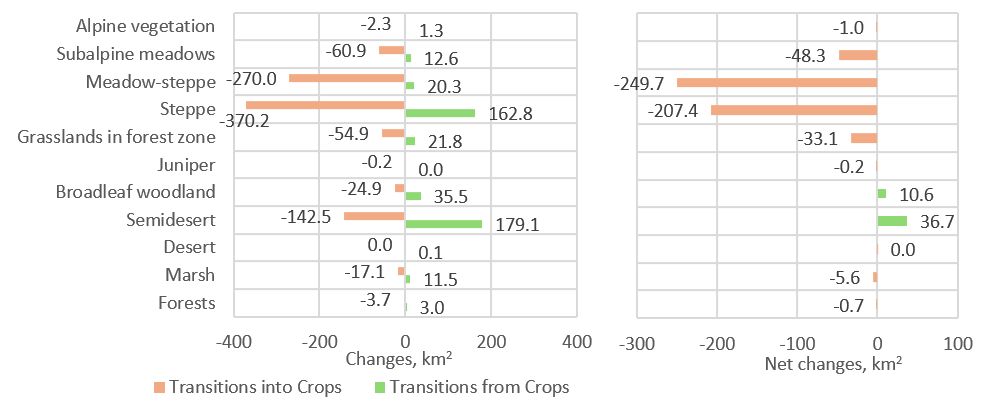 Նկար 23C-2. Բուսածածկության գոտիների և մշակաբույսերի հողատարածքների միջև անցումներ
Միայն զուտ տարածքային փոփոխությունները հաշվի չառնելով, այլև բնական էկոհամակարգերից մարդածին տարածքների և հակառակ անցումները հաշվի առնելը կենսական նշանակություն ունի կենսաբազմազանությունը պահպանելու և էկոհամակարգերի ամբողջական կարողությունը՝ էկոհամակարգային ծառայություններ մատուցելու համար։ Պարզ է, որ մշակվող հողատարածքներից կամ կառուցապատված տարածքներից անցումների արդյունքում էկոհամակարգային տարածքի ցանկացած նոր ավելացում ընդամենը անվանական է։ Մեր դեպքի ուսումնասիրության արդյունքում վեց տարվա ընթացքում մշակաբույսերի աճեցումից և կառուցապատումից ազատված տարածքները չեն վերականգնվել որպես գործառնական էկոհամակարգեր։ Իրականում դրանք լքված դաշտեր կամ անպիտան հողատարածքներ են, որոնք կենսաբազմազանության և էկոհամակարգային գործառույթների առումով շատ հեռու են բնական էկոհամակարգերից։ Այսպիսով, հաշվետու ժամանակահատվածում չփոխված էկոհամակարգերի վերջնական մակերեսը հավասար է սկզբնական մակերեսին՝ հանած հաշվետու ժամանակահատվածում տեղի ունեցած կրճատումները (Աղյուսակ 23C-2)։ Չփոխված բնական էկոհամակարգերի հաշվառումն իրականացնելու համար խորհուրդ է տրվում յուրաքանչյուր բուսածածկության գոտում հացահատիկային ցանքատարածքներից և կառուցապատված տարածքներից վերածված տարածքները նշանակել որպես «լքված դաշտեր և տարածքներ»: Այսպիսի հաշվառման դեպքում դրանց կրկին օգտագործումը չի նվազեցնի չփոխված էկոհամակարգերի հաշվետու տարածքը:
Ընդհանուր առմամբ, 2017-ից մինչև 2023 թվականը նվազել է մշակաբույսերի և կառուցապատ տարածքների չզբաղեցրած բուսածածկույթի տեսակների տարածքը։ բացառություններ են անտառային գոտու խոտածածկ տարածքները, կեռասենու անտառները և ալպյան բուսածածկույթը (Նկ. 23C-3)։ Ամենանշանակալից կրճատումները, թե՛ բացարձակ, թե՛ հարաբերական առումով, տեղի են ունեցել մարգագետին-ստեփում (254 կմ², 8,9%՝ 2017 թ. տարածքի նկատմամբ): Ստեփաններն ու անտառները նվազել են մոտ 4%-ով (համապատասխանաբար 211 կմ² և 139 կմ²): Մյուս բուսածածկույթի տեսակների նվազումները բացարձակ թվերով փոքր են՝ ընդամենը մի քանի քառակուսի կիլոմետր, իսկ անապատի համար՝ ընդամենը 0.2 կմ²:
Այնուամենայնիվ, էկոհամակարգային բազմազանության պահպանման համար նշանակություն ունեն ոչ միայն բացարձակ, այլև հարաբերական տարածքային փոփոխությունները, հատկապես փոքր ընդհանուր տարածք ունեցող էկոհամակարգերի դեպքում։ Այսպիսով, ճահճակների և անապատների տարածքի շատ փոքր բացարձակ փոփոխությունները համապատասխանում են համապատասխանաբար 2,61%-ի և 31%-ի հարաբերական նվազումներին, որոնք համեմատելի են ստեփայի և անտառի նվազումների հետ։ Մյուս խոսքով՝ էկոհամակարգային բազմազանության պահպանման նպատակով դրանք ոչ պակաս կարևոր են, քան ստեփեում և անտառում դիտարկված 100–200 կմ² կորուստները։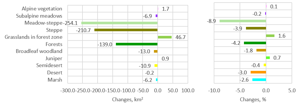 Նկար 23C-3. Բուսածածկույթի տեսակների մակերեսների զուտ փոփոխություններ 2017–2023 թվականներին
2017-ից 2023 թվականների ընթացքում բնական բուսածածկույթի տեսակների փոփոխությունները ամբողջական թվերով փոքր են՝ տասնյակ քառակուսի կիլոմետրերի չափով կամ պակաս։ Բնական բուսածածկույթի ամենանշանակալի բացարձակ կորուստները գրանցվել են ստեփեի և մարգագետին-ստեփեի գոտիներում, հատկապես Շիրակ, Գեղարքունիք և Լոռի մարզերում, ինչպես նաև Սյունիքի ճահճային անտառներում (Նկ. 23C-4a; Աղյուսակ 23C-3): Այնուամենայնիվ, հարաբերական առումով (2017 թվականի նկատմամբ կորցրած կամ ձեռք բերված տարածքի բաժինը, %), ծառածածկույթի ամենամեծ կորուստը գրանցվել է Արմավիրի մարզում, որտեղ ընդհանուր ծառածածկույթի տարածքը շատ փոքր է։ Փոփոխությունները ճահճակների և լայնատերև անտառների տարածքներում նույնպես նկատելի են դառնում, մինչդեռ դրանք ամբողջական թվերով գրեթե աննշան են (Նկ. 23C-4b; Աղյուսակ 23C-3)։
Աղյուսակ 23C-3. Բնական բուսածածկույթի տեսակների, անտրոպոգեն հողածածկույթի դասերի և ջրի (առանց Սևան լճի) տարածքը մարզերով 2017 և 2023 թվականներին և դրանց փոփոխությունները
| Ջուր | Մշակաբույսեր | Կառուցված | Ալպին | Սուբալպ | Մարգագետնատափաստան | Տափաստանային | Անտառային գոտու խոտածածկ տարածքներ | Արտակարգ վիճակ | Գիհի | Լայնատերեւ անտառ | Կիսաանապատ | Անապատ | Մարշ | Ընդամենը | ||
| 2017 թվականի տարածք, քմ² | Արագածոտն | 3.5 | 384 | 127.3 | 204.3 | 108.2 | 564.4 | 510.5 | 42.4 | 53.2 | 0 | 0 | 759.2 | 0 | 5.8 | 2762.8 |
| Արարատ | 39.8 | 356.1 | 144.3 | 37.2 | 62.6 | 30.8 | 730.7 | 174.7 | 30.4 | 0 | 9.5 | 425.1 | 7.1 | 46.2 | 2094.5 | |
| Արմավիր | 7.9 | 645.2 | 146.5 | 0 | 0 | 0 | 0 | 0 | 2.5 | 0 | 0 | 448 | 0 | 5.6 | 1255.7 | |
| Գեղարքունիք | 28.9 | 316.6 | 182.4 | 389.3 | 1292.6 | 420.5 | 878 | 230.9 | 133.6 | 20.7 | 8.8 | 0 | 0 | 93.9 | 3996.2 | |
| Կոտայք | 2.5 | 272.6 | 156.2 | 113.3 | 168.8 | 219.2 | 456.8 | 271.1 | 174 | 0 | 1.7 | 288.6 | 0 | 8.6 | 2133.4 | |
| Լոռի | 3.2 | 194.2 | 141.7 | 43.9 | 851.1 | 701.1 | 385.1 | 554.3 | 885.4 | 0 | 50.2 | 0 | 0 | 31.7 | 3841.9 | |
| Շիրակ | 27.2 | 547.7 | 140.2 | 127.9 | 427.1 | 512 | 910.9 | 0 | 13.4 | 0 | 0 | 17.4 | 0 | 40.2 | 2764 | |
| Սյունիք | 19.4 | 165.8 | 64.7 | 518.9 | 793.8 | 315.7 | 801.9 | 799.9 | 608.7 | 11.9 | 140.6 | 110.6 | 0 | 7.9 | 4359.8 | |
| Տավուշ | 4 | 91.6 | 93.1 | 0.3 | 205.2 | 0 | 5.9 | 536.6 | 1331.5 | 0 | 494.9 | 0 | 0 | 0 | 2763.1 | |
| Վայոց ձոր | 2.8 | 34.9 | 39.3 | 210.7 | 385.2 | 77.7 | 763.4 | 240.2 | 46.8 | 96.2 | 4.7 | 364.6 | 0 | 0.7 | 2267.2 | |
| Ընդամենը | 139.2 | 3008.7 | 1235.7 | 1645.8 | 4294.6 | 2841.4 | 5443.2 | 2850.1 | 3279.5 | 128.8 | 710.4 | 2413.5 | 7.1 | 240.6 | 28238.6 | |
| 2023 թվականի տարածք, քմ² | Արագածոտն | 3.4 | 443.4 | 140.3 | 204.5 | 107.1 | 502.7 | 517.5 | 42.9 | 48.9 | 0 | 0 | 746.6 | 0 | 5.3 | 2762.6 |
| Արարատ | 37.9 | 303.4 | 176.6 | 37.2 | 62.9 | 30.8 | 733.2 | 176.2 | 26.1 | 0 | 9.5 | 444.1 | 6.9 | 49.8 | 2094.6 | |
| Արմավիր | 6.7 | 609.6 | 183.2 | 0 | 0 | 0 | 0 | 0 | 0.4 | 0 | 0 | 448.8 | 0 | 6.9 | 1255.6 | |
| Գեղարքունիք | 28.2 | 407.2 | 192.9 | 389.9 | 1280.8 | 400.3 | 817.8 | 227 | 127.9 | 20.8 | 10.6 | 0 | 0 | 92.8 | 3996.2 | |
| Կոտայք | 2.6 | 267.5 | 183.8 | 113.9 | 175.9 | 221.7 | 451.6 | 272.6 | 155.1 | 0 | 1.7 | 278.8 | 0 | 8.2 | 2133.4 | |
| Լոռի | 4.7 | 307.2 | 151.5 | 45 | 847.9 | 649.5 | 337.3 | 526.4 | 899.2 | 0 | 41.8 | 0 | 0 | 31.3 | 3841.8 | |
| Շիրակ | 30.9 | 758 | 145.5 | 128.3 | 403.9 | 413.5 | 823.9 | 0 | 13.7 | 0 | 0 | 17.3 | 0 | 29 | 2764 | |
| Սյունիք | 15 | 228.7 | 72 | 524.3 | 813.1 | 291.1 | 781.4 | 871.8 | 487.4 | 12.6 | 145.7 | 110.2 | 0 | 6.5 | 4359.8 | |
| Տավուշ | 4.4 | 82.1 | 97.7 | 0.3 | 210.9 | 0 | 6.5 | 534 | 1343.7 | 0 | 483.5 | 0 | 0 | 0 | 2763.1 | |
| Վայոց ձոր | 2.3 | 32.9 | 44.9 | 210.7 | 385.1 | 77.7 | 763.3 | 246 | 37.9 | 96.3 | 4.6 | 364.7 | 0 | 0.8 | 2267.2 | |
| Ընդամենը | 136.1 | 3440 | 1388.4 | 1654.1 | 4287.6 | 2587.3 | 5232.5 | 2896.9 | 3140.3 | 129.7 | 697.4 | 2410.5 | 6.9 | 230.6 | 28238.3 | |
| Փոխարկում, քառ. կմ | Արագածոտն | 0 | 59.4 | 13 | 0.1 | -1.1 | -61.7 | 7.1 | 0.4 | -4.2 | 0 | 0 | -12.6 | 0 | -0.5 | |
| Արարատ | -1.9 | -52.8 | 32.4 | -0.1 | 0.3 | 0 | 2.5 | 1.4 | -4.3 | 0 | 0 | 19 | -0.2 | 3.7 | ||
| Արմավիր | -1.2 | -35.6 | 36.7 | 0 | 0 | 0 | 0 | 0 | -2.1 | 0 | 0 | 0.9 | 0 | 1.3 | ||
| Գեղարքունիք | -0.7 | 90.6 | 10.5 | 0.6 | -11.8 | -20.2 | -60.2 | -3.9 | -5.7 | 0 | 1.8 | 0 | 0 | -1.1 | ||
| Կոտայք | 0.1 | -5.1 | 27.6 | 0.6 | 7.1 | 2.5 | -5.3 | 1.5 | -18.9 | 0 | 0 | -9.7 | 0 | -0.4 | ||
| Լոռի | 1.5 | 113 | 9.8 | 1.1 | -3.1 | -51.6 | -47.8 | -27.9 | 13.8 | 0 | -8.4 | 0 | 0 | -0.4 | ||
| Շիրակ | 3.7 | 210.3 | 5.2 | 0.4 | -23.2 | -98.5 | -86.9 | 0 | 0.3 | 0 | 0 | -0.1 | 0 | -11.2 | ||
| Սյունիք | -4.4 | 62.8 | 7.3 | 5.4 | 19.3 | -24.6 | -20.5 | 71.9 | -121.3 | 0.7 | 5.1 | -0.4 | 0 | -1.4 | ||
| Տավուշ | 0.4 | -9.4 | 4.6 | 0 | 5.6 | 0 | 0.6 | -2.6 | 12.2 | 0 | -11.4 | 0 | 0 | 0 | ||
| Վայոց ձոր | -0.4 | -1.9 | 5.6 | 0 | -0.1 | 0 | -0.1 | 5.7 | -8.9 | 0.2 | -0.1 | 0 | 0 | 0 | ||
| Ընդամենը | -2.9 | 431.3 | 152.7 | 8.1 | -7 | -254.1 | -210.6 | 46.5 | -139.1 | 0.9 | -13 | -2.9 | -0.2 | -10 | ||
| Փոփոխություն՝ 2017 թվականի նկատմամբ, % | Արագածոտն | -0.2 | 15.5 | 10.2 | 0.1 | -1 | -10.9 | 1.4 | 1 | -8 | 0 | 0 | -1.7 | 0 | -8.7 | |
| Արարատ | -4.9 | -14.8 | 22.4 | -0.2 | 0.5 | 0.1 | 0.3 | 0.8 | -14.1 | 0 | 0 | 4.5 | -3 | 7.9 | ||
| Արմավիր | -14.9 | -5.5 | 25 | 0 | 0 | 0 | 0 | 0 | -83.5 | 0 | 0 | 0.2 | 0 | 23.1 | ||
| Գեղարքունիք | -2.3 | 28.6 | 5.7 | 0.2 | -0.9 | -4.8 | -6.9 | -1.7 | -4.2 | 0.1 | 20.5 | 0 | 0 | -1.2 | ||
| Կոտայք | 3.2 | -1.9 | 17.7 | 0.6 | 4.2 | 1.2 | -1.2 | 0.6 | -10.9 | 0 | 0.1 | -3.4 | 0 | -4.6 | ||
| Լոռի | 48.3 | 58.2 | 6.9 | 2.5 | -0.4 | -7.4 | -12.4 | -5 | 1.6 | 0 | -16.7 | 0 | 0 | -1.1 | ||
| Շիրակ | 13.7 | 38.4 | 3.7 | 0.3 | -5.4 | -19.2 | -9.5 | 0 | 2.3 | 0 | 0 | -0.5 | 0 | -27.9 | ||
| Սյունիք | -22.8 | 37.9 | 11.2 | 1 | 2.4 | -7.8 | -2.6 | 9 | -19.9 | 6.2 | 3.7 | -0.4 | 0 | -17.3 | ||
| Տավուշ | 9.3 | -10.3 | 5 | 0 | 2.7 | 0 | 10.3 | -0.5 | 0.9 | 0 | -2.3 | 0 | 0 | 0 | ||
| Վայոց ձոր | -14.9 | -5.5 | 14.2 | 0 | 0 | 0 | 0 | 2.4 | -19 | 0.2 | -2.1 | 0 | 0 | 0.6 |
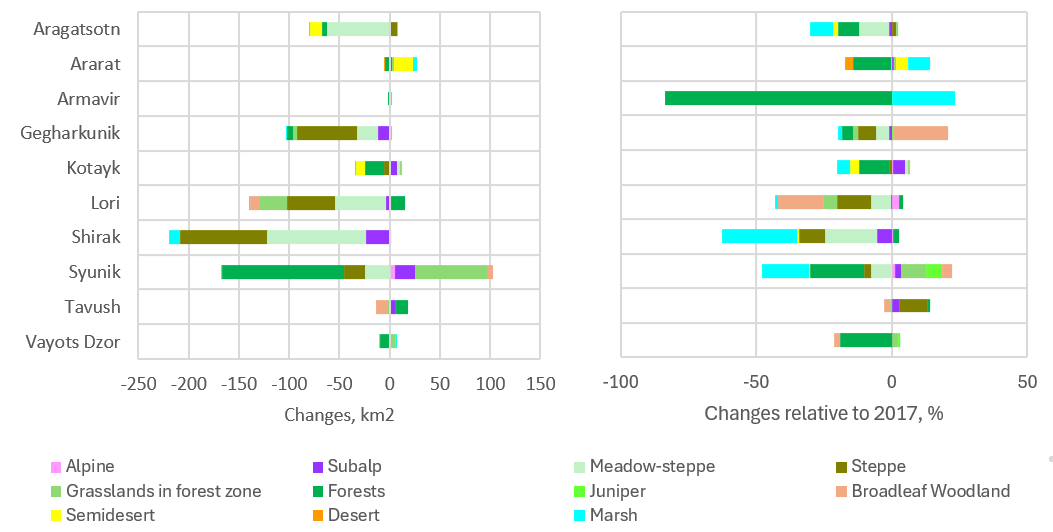 Նկ. 23C-4. Բուսածածկույթի տեսակների բնական տարածքի փոփոխություններ ըստ մարզերի 2017–2023 թթ.՝ ա) ամբողջական փոփոխություններ, կմ²; բ) կորցված/ստացված տարածքի բաժին, %՝ 2017 թ. նկատմամբ։
2.3.D. 1961 թ. բուսածածկույթի քարտեզում հայտնաբերված բուսականության տեսակների հնարավոր տարածքի կրճատում
Այս վերլուծության համար Հայկական ԽՍՀ 1961-ի ատլասի բուսականության քարտեզը (թվայնացված է. Վարդան Ասատրյան) և օգտագործվել են ESRI-ի 2023 թ. հողածածկույթի տվյալները։ 2023 թ. ESRI տվյալների հիման վրա բացառելով մշակաբույսերի հողամասերն ու կառուցապատված տարածքները՝ ներկայիս բուսածածկության տեսակների գոտիները համարվել են պոտենցիալ բուսածածկության գոտիներ։
Այս վերլուծությունը հաշվի է առնում միայն 1961 թվականին քարտեզագրված բուսականության տեսակների հնարավոր տարածման գոտիները։ Բուսականության իրական առկայությունը պահանջում է դաշտային հետազոտությունների միջոցով ստուգում։
Բուսականության քարտեզ 1961 թ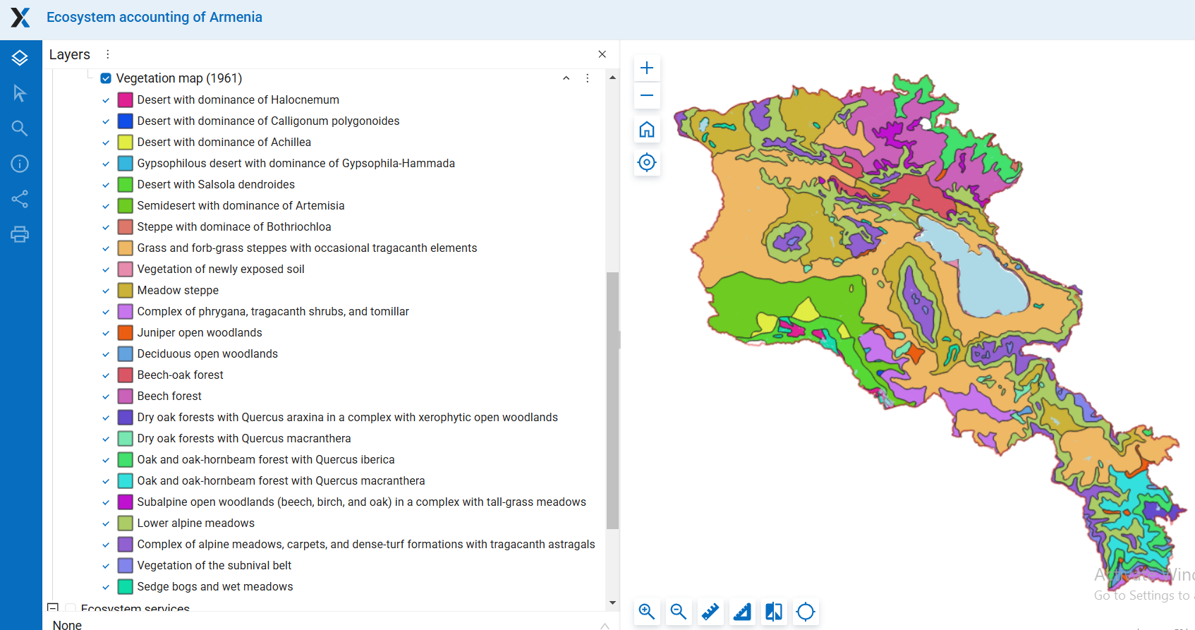
Բուսականության քարտեզ՝ բացառելով մշակաբույսերը և կառուցապատված տարածքները ESRI 2023-ից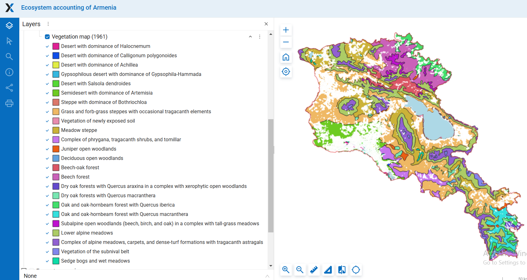
Մանրամասն քարտեզների համար տես Բաժին Էկոհամակարգի տարածություն/բուսականություն
Բուսականության տեսակների դասակարգումը ըստ նրանց ներկայիս հազվադեպության ցույց է տալիս, որ ներկայումս բոլոր անապատային տեսակները (1–5) ինչպես նաև Bothriochloa-ի գերիշխող ստեփպը (տեսակ 7) ամենահազվադեպն են։ Յուրաքանչյուրը զբաղեցնում է 100 քմ-ից պակաս տարածք։ ESRI տվյալներով երկու ամենահազվադեպ անապատային տեսակների (2 և 4) հնարավոր տարածքները, որոնց յուրաքանչյուրը զբաղեցնում է 10 քմ-ից պակաս, մեծապես պահպանվել են և հիմնականում չեն ծածկվում մշակաբույսերի դաշտերով կամ կառուցապատված տարածքներով։ Բոթրիոխլոայի գերիշխող ստեփայի (7) տարածքը նույնպես, թվում է, համեմատաբար լավ է պահպանվել։
Ամենածանր տուժել է Achillea (3)-ի գերիշխող անապատային տարածքը, որից մնացել է ընդամենը 7%, ինչպես նաև Salsola dendroides (5)-ով անապատային տարածքը, որից մնացել է ընդամենը 16%։ Halocnemum (1)-ի գերիշխող անապատային տարածքը նույնպես զգալիորեն կրճատվել է՝ մնալով 43%։ Այս երեք բուսածածկույթի տեսակներն են քարտեզում ներկայացված բոլոր տեսակների մեջ ամենամեծ նվազումը գրանցել։
Հարաբերականորեն հազվադեպ բուսածածկույթի տեսակներ, որոնք զբաղեցնում են 100–200 քառ. կմ տարածք՝ տերևաթափ և կեռասենյաց բաց անտառներ (12, 13) և կաղնու անտառների տարբերակներ (16, 17), ունեն համեմատաբար լավ պահպանված տարածման շրջաններ, որոնցում մնացել է 85–99%։
Ավելի լայնորեն տարածված բուսածածկույթի տեսակների մեջ, որոնք զբաղեցնում են 200–1 000 կմ², նշանակալի նվազում արձանագրվել է միայն բարդախոտային ճահճակների և խոնավ արոտների (24-րդ տեսակ) համար, որոնք նվազել են մինչև 63%։ Այլ տեսակների տարածքները՝ ենթասառնային բուսականություն, ենթալպյան բաց անտառներ, կաղնու և կաղնու-ծառի անտառների տարբերակներ, ինչպես նաև թփուտներ, մեծապես անփոփոխ են մնացել մարդկային գործունեության արդյունքում՝ նրանց տարածքի 94–100%-ը պահպանվել է անփոփոխ։
1000 կմ²-ից ավելի տարածք զբաղեցնող սովորական և լայնորեն տարածված բուսականության տեսակների մեջ նկատվել են զգալի կրճատումներ կիսաանապատային գոտում, որտեղ գերիշխում է Artemisia-ն (տեսակ 6)՝ մնացել է 57%, և ամենատարածված բուսականության գոտում՝ խոտաբույսերի և բազմամյա խոտաբույսերի ստեփպեր (տեսակ 8), որտեղ մնացել է 75%, երկուսն էլ գտնվում են հողագործական մշակման ենթակա տարածքներում։
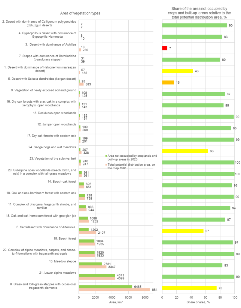
Նկ. 23D-2. Բուսածածկույթի տեսակների պոտենցիալ տարածքները և դրանց ներկայիս վիճակը: ա) յուրաքանչյուր բուսածածկույթի տեսակի պոտենցիալ տարածքը և 2023 թ. դրությամբ մնացած տարածքը; բուսածածկույթի տեսակները դասակարգված են ըստ 2023 թ. դրությամբ դրանց հազվադեպության; բ) մշակաբույսերի դաշտերով և կառուցապատված տարածքներով չզբաղեցված տարածքի մասնաբաժինը ընդհանուր պոտենցիալ բաշխման տարածքի նկատմամբ, %.
Աղյուսակ 23D-1. Բուսածածկույթի տեսակների հնարավոր և ներկայիս տարածքները և դրանց պահպանվածության աստիճանը
| Ընդհանուր պոտենցիալ տարածման տարածքը քարտեզի վրա 1961 թ., կմ2 | 2023 թվականին մշակաբույսերի և կառուցապատված տարածքների չզբաղեցրած մակերեսը, կմ² | Հողագործական և կառուցապատված տարածքներով չզբաղեցված տարածքի մասնաբաժինը ընդհանուր հնարավոր տարածման տարածքի նկատմամբ, % | |
| 1. Հալոկնեմումի գերիշխող անապատ (սարսազան անապատ) | 135.1 | 57.5 | 42.5 |
| 2. Calligonum polygonoides-ի գերիշխող անապատ (ջուզգուն անապատ) | 7.4 | 6.6 | 89.6 |
| 3. Ախիլեայի գերիշխող անապատ | 256.0 | 17.6 | 6.9 |
| 4. Գիպսոֆիլային անապատ՝ Գիպսոֆիլա-Համադայի գերիշխմամբ | 9.8 | 8.1 | 82.6 |
| 5. Salsola dendroides-ով անապատ (կարգան անապատ) | 582.7 | 95.3 | 16.4 |
| 6. Արտեմիսիայի գերիշխող կիսաանապատ | 2107.2 | 1201.5 | 57.0 |
| 7. Բոթրիոխլոայի գերիշխող ստեփա (մորուքաբույսային ստեփա) | 39.1 | 31.3 | 80.0 |
| 8. Խոտածածկ և խոտածածկ տափաստաններ՝ երբեմն տրագականտի տարրերով | 8614.1 | 6464.9 | 75.1 |
| 9. Նոր բացված հողի և հողի բուսականությունը | 124.5 | 107.8 | 86.6 |
| 10. Մարգագետնային տափաստան | 3347.4 | 2781.2 | 83.1 |
| 11. ֆրիգանայի, տրագականտի թփերի և տոմիլարի համալիր | 944.1 | 886.5 | 93.9 |
| 12. Գիհու բաց անտառներ | 209.5 | 198.9 | 94.9 |
| 13. Տերեւաթափ բաց անտառներ | 153.5 | 151.6 | 98.8 |
| 14. Հաճարենու-կաղնու անտառ | 650.5 | 625.7 | 96.2 |
| 15. Բեժի անտառ | 1934.6 | 1884.0 | 97.4 |
| 16. Ցամաքային կաղնու անտառներ՝ արաքի կաղնու մասնակցությամբ, զիխերոֆիտ բաց անտառային տարածքների համալիրում | 143.1 | 121.1 | 84.6 |
| 17. Արևելյան կաղնիներով չոր կաղնու անտառներ | 200.9 | 199.1 | 99.1 |
| 18. Կաղնու և կաղնու բոխի անտառ վրացական ջակով | 1252.1 | 1088.1 | 86.9 |
| 19. Կաղնու և կաղնու-բոխու անտառ՝ արևելյան կաղնու հետ | 737.8 | 728.2 | 98.7 |
| 20. Ենթալպյան բաց անտառներ (հաճարենի, կեչի և կաղնի) բարձր խոտածածկ մարգագետիններով համալիրում | 360.6 | 360.5 | 100.0 |
| 21. Ստորին ալպիական մարգագետիններ | 4398.9 | 4370.6 | 99.4 |
| 22. Ալպիական մարգագետինների, գորգերի և խիտ խոտածածկ գոյացությունների համալիր տրագականթ աստղագալներով | 1932.9 | 1919.6 | 99.3 |
| 23. Ենթամաշկային գոտու բուսականություն | 246.7 | 245.7 | 99.6 |
| 24. Ծիծեռնակային ճահիճներ և թաց մարգագետիններ | 327.8 | 207.2 | 63.2 |
Հայկական ԽՍՀ Ատլաս։ խմբ. Բաղդասարյան Ա.Բ., Դավթյան Գ.Ս., Հարությունյան Ա.Բ., Մարտիրոսյան Գ.Մ., Մարուխյան Ա.Գ., Մկրտչյան Ս.Ս., Շախբազյան Մ.Ս., Ստեփանյան Լ.Ա. (նախագահ), Ուրուսով Վ.Վ. Հայկական ԽՍՀ Գիտությունների ակադեմիա։ Գեոդեզիայի և քարտեզագրության գլխավոր տնօրինություն։ Երևան – Մոսկվա, 1961
Բարսեղյան Ա. Հայկական ֆլորա։ «Հայաստանի Ազգային Ատլաս», շարք։ 2007 թ.