Ներողություն ենք խնդրում կայքի մեքենայական թարգմանության հնարավոր սխալների համար
2.4. Բնական լանդշաֆտների տարածվածությունը
Աշխարհագրական տեղեկատվական համակարգերի մոդելավորում և վերլուծություն – Էդուարդ Կազակով (NextGIS OÜ, Էստոնիա)
Արդյունքների վերլուծություն և ներկայացում – Ելենա Բուկվարևա (ԲԿԿ-Հայաստան)
1. Արցախում բնական լանդշաֆտների տարածվածությունը
Բնական լանդշաֆտների տարածքի գնահատման համար օգտագործվել է ԱՀԿ-ին ներկայացված Հինգերորդ ազգային զեկույցում (2014) հրապարակված լանդշաֆտային գոտիների քարտեզը (թվային տարբերակով հասանելի է «Հայաստանի անտառային атլաս»-ում)։ FAA), ինչպես նաև համեմատության համար՝ ESRI-ի 2017 և 2023 թվականների հողածածկույթի տվյալները և ESA-ի 2021 թվականի տվյալները։
Բնական լանդշաֆտների տարածքը հաշվարկվել է որպես տվյալ լանդշաֆտային գոտու մակերեսը՝ հանած ջրային մարմիններն ու մարդածին վերափոխված տարածքները, այսինքն՝ կառուցապատված տարածքներն ու հացահատիկային ցանքատարածքները։
Լանդշաֆտային գոտիներ 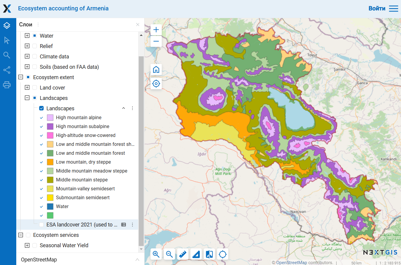
Հողածածկ ESA 2021 Հողատարածք ESRI 2023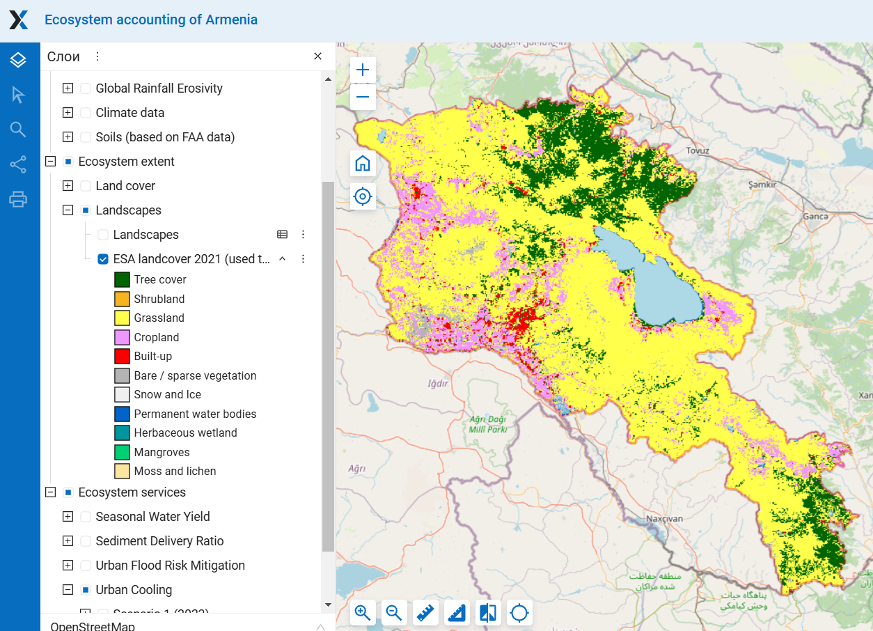
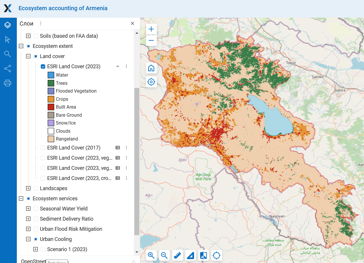 Նկ. 1. Բնական լանդշաֆտների տարածքի գնահատման համար օգտագործվող քարտեզներ Մանրամասն քարտեզների համար տե՛ս «Էկոհամակարգի ծավալը» բաժինը
Ըստ ESRI տվյալների՝ մարդու կողմից առավել վերափոխված գոտին լեռնային հովտային կիսաանապատն է, որտեղ բնական լանդշաֆտներից մնացել է ընդամենը 27%։ Այն հաջորդում են ցածր լեռնային չոր ստեփեի և միջին լեռնային ստեփեի գոտիները, որտեղ համապատասխանաբար պահպանվել է 65% և 71% բնական լանդշաֆտ։ Բարձր լեռնային ձյունածածկ, ալպյան և ենթալպյան գոտիները գրեթե անփոփոխ են մնացել մարդկային գործունեության ազդեցությունից։ Անտառները առավել լայնորեն տարածված են ցածր-միջին լեռնային անտառային գոտում (38%) և ցածր-միջին լեռնային անտառային պաշտպանական գոտում (17%)։ Լանդշաֆտային գոտիների կեսում՝ բարձր լեռնային ձյունածածկ, ալպյան, չոր ստեփա և կիսաանապատներ, անտառներ գրեթե չկան։ (Նկ. 2; Սեղաններ).
ESA տվյալները ընդհանուր առմամբ նման պատկեր են ցույց տալիս, սակայն կառուցապատված տարածքի մակերեսը փոքր է, իսկ ծառածածկույթի և մերկ հողի մակերեսները՝ մեծ, ինչը հատկապես նկատելի է կիսաանապատներում, չոր ստեփում և անտառային պաշտպանիչ գոտում (Նկ. 2): Սեղաններ). Դրա պատճառներից մեկը, ինչպես վերևում նշվեց, այն է, որ ESA-ն բնակավայրերում գտնվող ծառերը նույնպես նույնացնում է։ ESA տվյալներում լեռան ստորոտի կիսաանապատային գոտում ծառերի առկայությունը ամբողջությամբ պայմանավորված է այս գործոնով՝ այնտեղի բոլոր ծառերը գտնվում են բնակավայրերի ներսում (տես Բաժին 2.1.A)։ Կիսաանապատային գոտում ESRI-ի կողմից որպես մշակաբույսերի հողեր դասակարգված որոշ տարածքներ ESA-ն ճանաչել է մերկ հող և խոտածածկ տարածքներ։ Արդյունքում՝ ESA տվյալներում այս գոտու վերափոխման աստիճանը զգալիորեն ցածր է, քան ESRI տվյալներում։
 Նկ. 2. Լանդշաֆտային գոտիներում հողածածկույթի դասերի բաժինը
Նկար 3. Լանդշաֆտային գոտիներում բնական հողածածկույթի դասերի տարածքի բաժինը (%) Ըստ ESRI-ի և ESA-ի տվյալների
Աղյուսակ 1. Լանդշաֆտային գոտիներում հողածածկույթի դասերի տարածքը ըստ ESRI 2023-ի տվյալների, կմ2
| Ծառեր | Rangeland | Մերկ հող | Ձյուն/Սառույց | Ջուր/ Ջրհեղեղված բանջարեղեն | Մշակաբույսեր | Կառուցված տարածք | Ընդամենը | |
| Բարձրադիր ձյունածածկ | 0.06 | 183.27 | 3.83 | 7.09 | 0.32 | 1.01 | 0.00 | 195.58 |
| Բարձր լեռնային ալպյան | 9.90 | 1948.68 | 5.67 | 4.45 | 1.83 | 3.72 | 1.38 | 1975.62 |
| Բարձր լեռնային ենթալպյան | 125.93 | 4222.75 | 3.73 | 0.00 | 2.73 | 49.13 | 10.25 | 4414.52 |
| Միջին լեռնային մարգագետնային տափաստան | 294.31 | 4057.45 | 4.27 | 0.00 | 27.14 | 460.92 | 78.35 | 4922.44 |
| Միջին լեռնային տափաստան | 108.88 | 4723.60 | 2.97 | 0.00 | 20.69 | 1454.46 | 484.65 | 6795.24 |
| Ցածր լեռնային, չոր տափաստանային | 3.21 | 1461.86 | 3.35 | 0.00 | 5.61 | 454.76 | 329.90 | 2258.69 |
| Ցածր-միջին լեռնային անտառ | 2361.03 | 2261.51 | 2.81 | 0.00 | 50.26 | 133.77 | 180.49 | 4989.87 |
| Ցածր-միջին լեռ: անտառային ապաստարանի գոտի | 195.79 | 796.09 | 3.87 | 0.00 | 6.34 | 95.20 | 84.08 | 1181.37 |
| Լեռնահովտային կիսաանապատ | 0.52 | 411.32 | 5.75 | 0.00 | 144.50 | 766.06 | 376.07 | 1704.21 |
| Ենթալեռ կիսաանապատ | 0.00 | 14.93 | 0.03 | 0.00 | 0.20 | 0.19 | 1.97 | 17.33 |
| Սևան | 0 | 0 | 0 | 0 | 1227 | 0 | 0 | 1227.00 |
Աղյուսակ 2. Լանդշաֆտային գոտիներում հողածածկույթի դասերի տարածքները՝ ըստ ESA 2021-ի տվյալների, կմ2
| Ծառի ծածկը | Խոտածածկավայր | Թփուտ-հող | Մախող/ լայքեն | Բաց/ հազվադեպ բուսականություն | Ձյուն/ սառույց | Ջուր/ խոնավավայրեր | Բուսաբուծություն | Կառուցված | Ընդամենը | |
| Բարձրադիր ձյունածածկ | 0.01 | 189.85 | 0.00 | 8.91 | 34.14 | 0.44 | 1.37 | 0.00 | 0.00 | 234.72 |
| Բարձր լեռնային ալպյան | 22.95 | 1814.63 | 0.00 | 25.59 | 106.82 | 0.11 | 2.24 | 5.78 | 0.11 | 1978.24 |
| Բարձր լեռնային ենթալպյան | 189.42 | 4066.87 | 0.00 | 6.11 | 45.19 | 0.01 | 1.87 | 78.13 | 3.13 | 4390.74 |
| Միջին լեռնային մարգագետնային տափաստան | 391.79 | 4088.71 | 0.00 | 0.92 | 21.20 | 0.00 | 28.58 | 404.81 | 22.02 | 4958.03 |
| Միջին լեռնային տափաստան | 283.17 | 4578.27 | 0.18 | 0.00 | 69.91 | 0.00 | 23.36 | 1688.78 | 191.46 | 6835.12 |
| Ցածր լեռնային, չոր տափաստանային | 90.96 | 1549.08 | 0.00 | 0.00 | 165.79 | 0.00 | 5.12 | 289.93 | 167.83 | 2268.72 |
| Ցածր-միջին լեռնային անտառ | 2751.63 | 2034.38 | 2.97 | 0.00 | 10.54 | 0.00 | 3.74 | 122.38 | 62.19 | 4987.84 |
| Ցածր-միջին լեռ: անտառային ապաստարանի գոտի | 327.59 | 695.87 | 6.82 | 0.00 | 14.03 | 0.00 | 5.26 | 103.17 | 31.54 | 1184.29 |
| Լեռնահովտային կիսաանապատ | 36.26 | 458.47 | 0.00 | 0.00 | 160.83 | 0.00 | 39.78 | 706.90 | 206.75 | 1608.98 |
| Ենթալեռ կիսաանապատ | 1.78 | 13.08 | 0.00 | 0.00 | 1.09 | 0.00 | 0.16 | 0.03 | 0.94 | 17.08 |
| Սևան | 0.00 | 0.00 | 0.00 | 0.00 | 0.00 | 0.00 | 1279.24 | 0.00 | 0.00 | 1279.24 |
Լանդշաֆտային գոտիներում բնական տարածքների ծավալը զգալիորեն տարբերվում է այդ գոտիների ընդհանուր ծավալից (Նկ. 4). Երբ համեմատում ենք լանդշաֆտային գոտիների ընդհանուր մակերեսը, միջին լեռնային ստեփերը զգալիորեն գերազանցում են մյուս բոլոր լանդշաֆտային գոտիներին։ Սակայն, եթե բացառենք անթրոպոգեն տարածքները, բնական լանդշաֆտների չորս տեսակներ ունեն նման մակերեսներ՝ յուրաքանչյուրը ծածկում է 15–16% Արցախի տարածքի՝ միջին լեռնային ստեփե, խոտածածկ ստեփե, ենթալպյան և անտառային գոտիներ։ Լեռնային-ձորային կիսաանապատային գոտին կրճատվում է առավելագույնս՝ 5.41%-ից մինչև 1.4–2.31%, քանի որ մարդկային գործունեության ազդեցությամբ այն ամենաշատն է վերափոխվել։ ESRI-ի և ESA-ի կողմից բնական լանդշաֆտների գնահատված տարածքների միջև տարբերությունները առավել մեծ են մարդկային գործունեության ազդեցությամբ առավել վերափոխված գոտիներում, քանի որ ESA-ն մշակաբույսերի և կառուցապատված հողերի համար նշում է ավելի փոքր տարածքներ (տես վերևում)։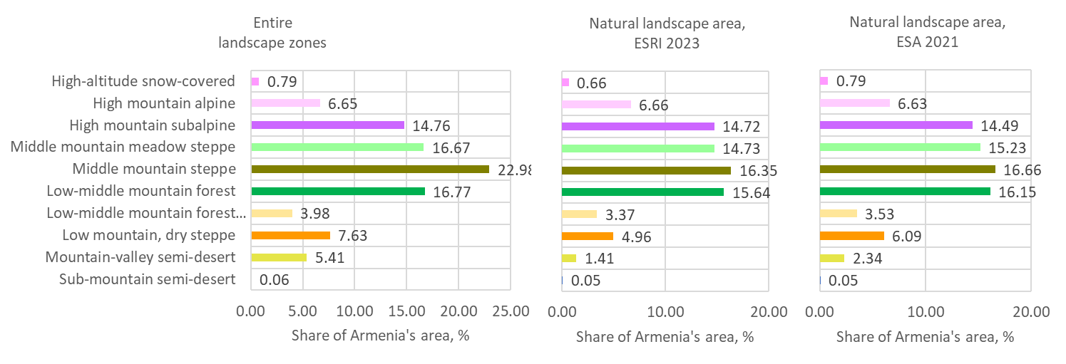
Նկար 4. Լանդշաֆտային գոտիների և բնական լանդշաֆտների մասնաբաժինը Հայաստանի ընդհանուր տարածքի %-ում
2. Լանդշաֆտի տարածքի փոփոխություններ 2017-ից մինչև 2023 թվականը ESRI-ի տվյալների համաձայն
Բնական լանդշաֆտների մեծ մասի տարածքը 2017-ից 2023 թվականներին նվազել է մարդու կողմից զբաղեցված տարածքների (մշակովի հողեր և կառուցապատված գոտիներ) ընդլայնման պատճառով, ինչպես նկարագրված է «…» բաժնում։Հողածածկույթի դասերի ծավալը«Բնական տարածքի նկատելի աճ նկատվել է միայն լեռնահովտային կիսաանապատում։ Սակայն կարևոր է հիշել, որ բնական համայնքների վերականգնումը պահանջում է երկար ժամանակահատված։» 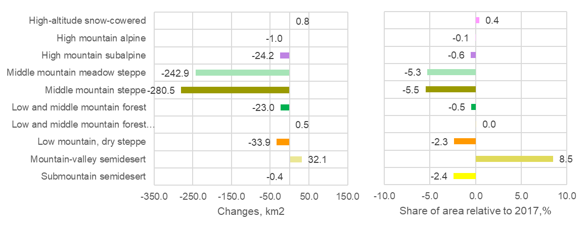 Նկ. 5. Բնական լանդշաֆտի տարածքի ամբողջական և հարաբերական փոփոխություններ
3. Մարսի մակարդակ
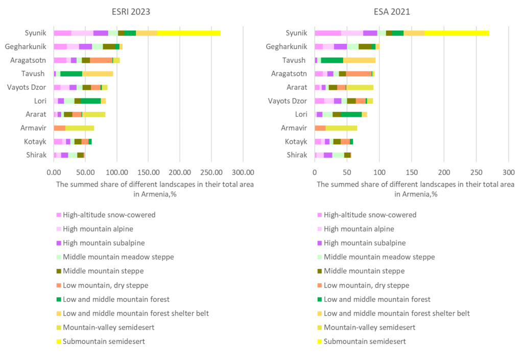
Մարզերում բնական լանդշաֆտների տարածվածության առումով ESRI-ն և ESA-ն ներկայացնում են շատ նման պատկեր։ Անտառային լանդշաֆտային գոտու հիմնական մասը գտնվում է երեք մարզերում՝ Լոռի, Տավուշ և Սյունիք։ Ալպյան և ենթալպյան լանդշաֆտների ամենամեծ տարածքները գտնվում են Սյունիքում և Գեղարքունիքում, թեև այս լանդշաֆտները նկատելի են նաև բոլոր մյուս մարզերում՝ բացի Արմավիրից և Տավուշից։ Ստեփային լանդշաֆտներ կան բոլոր մարզերում, սակայն Տավուշի և Արմավիրի մարզերում դրանց տարածքը փոքր է։ Լեռնային հովտային կիսաանապատի մնացած բնական տարածքները հիմնականում գտնվում են Արարատի և Արմավիրի մարզերում։ Լեռան ստորոտային կիսաանապատը ներկայացված է միայն փոքր կղզիներով Սյունիքի մարզի հարավում։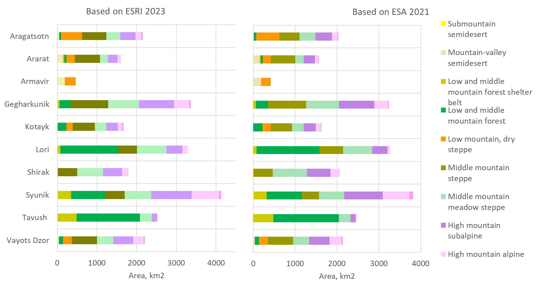
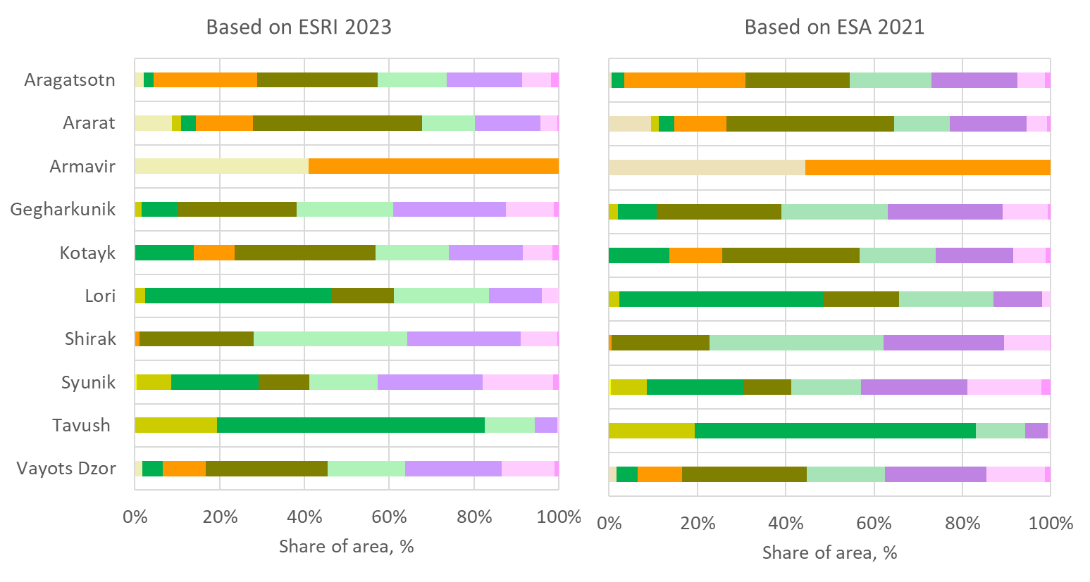 Նկար 6. Մարզերում բնական լանդշաֆտների տարածքը և մասնաբաժինը
Աղյուսակ 3. Բնական լանդշաֆտների տարածք, կմ², հիմնված ESRI 2023-ի հողածածկույթի տվյալների վրա
| Լանդշաֆտային գոտի | Արագած-ոտն | Արարատ | Արմավիր | Գեղարքունիք | Կոտայք | Լոռի | Շիրակ | Սյունիք | Տավուշ | Վայոց ձոր | Հայաստան |
| Բարձրադիր ձյունածածկ | 39.1 | 5.9 | 0.0 | 40.2 | 26.2 | 0.0 | 7.5 | 54.5 | 0.0 | 20.9 | 194.2 |
| Բարձր լեռնային ալպյան | 146.4 | 62.6 | 0.0 | 380.5 | 114.8 | 134.5 | 152.9 | 688.8 | 10.2 | 278.0 | 1968.7 |
| Բարձր լեռնային ենթալպյան | 383.5 | 245.1 | 0.0 | 892.1 | 290.0 | 407.7 | 479.4 | 1021.6 | 134.1 | 499.5 | 4352.8 |
| Միջին լեռնային մարգագետնային տափաստան | 351.3 | 199.8 | 0.0 | 768.9 | 288.0 | 735.7 | 648.7 | 664.7 | 294.6 | 404.3 | 4356.1 |
| Միջին լեռնային տափաստան | 611.2 | 631.7 | 0.0 | 943.5 | 553.7 | 481.4 | 482.9 | 494.4 | 0.0 | 636.7 | 4835.5 |
| Ցածր լեռնային, չոր տափաստանային | 527.8 | 214.3 | 272.5 | 0.0 | 160.4 | 0.0 | 19.0 | 0.0 | 0.0 | 224.1 | 1418.2 |
| Ցածր/միջին լեռնային անտառ | 50.1 | 55.7 | 0.0 | 284.5 | 231.3 | 1448.1 | 0.0 | 854.0 | 1595.4 | 106.3 | 4625.4 |
| Ցածր/միջին լեռնային անտառային ապաստարան | 0.0 | 33.7 | 0.0 | 53.3 | 0.0 | 81.3 | 0.0 | 338.2 | 489.3 | 0.0 | 995.8 |
| Լեռնահովտային կիսաանապատ | 45.1 | 139.6 | 189.3 | 0.0 | 0.0 | 0.0 | 0.0 | 0.0 | 0.0 | 37.0 | 411.1 |
| Ենթալեռ կիսաանապատ | 0.0 | 0.0 | 0.0 | 0.0 | 0.0 | 0.0 | 0.0 | 15.0 | 0.0 | 0.0 | 15.0 |
Աղյուսակ 4. Բնական լանդշաֆտների մակերեսը, կմ2, հիմնված ESA 2021 ցամաքային ծածկույթի տվյալների վրա
| Լանդշաֆտային գոտի | Արագած-ոտն | Արարատ | Արմա-վիր | Գեղարքունիք | Կոտայք | Լոռի | Շիրակ | Սյունիք | Տավուշ | Վայոց ձոր | Հայաստան |
| Բարձրադիր ձյունածածկ | 25.6 | 13.7 | 0.0 | 24.8 | 19.2 | 0.0 | 5.1 | 81.2 | 0.0 | 29.6 | 199.2 |
| Բարձր լեռնային ալպյան | 128.2 | 72.6 | 0.0 | 331.2 | 119.1 | 63.1 | 212.4 | 639.3 | 16.7 | 282.8 | 1865.4 |
| Բարձր լեռնային ենթալպյան | 393.5 | 271.4 | 0.0 | 842.9 | 287.5 | 361.7 | 561.3 | 919.2 | 127.2 | 489.4 | 4254.1 |
| Միջին լեռնային մարգագետնային տափաստան | 378.0 | 195.1 | 0.0 | 778.4 | 279.1 | 699.1 | 811.6 | 601.3 | 274.1 | 376.5 | 4393.0 |
| Միջին լեռնային տափաստան | 478.6 | 591.4 | 0.0 | 915.3 | 506.6 | 562.9 | 457.4 | 411.9 | 0.2 | 604.4 | 4528.6 |
| Ցածր լեռնային, չոր տափաստանային | 555.8 | 184.8 | 232.9 | 0.0 | 195.7 | 0.0 | 11.2 | 0.0 | 0.0 | 213.2 | 1393.7 |
| Ցածր/միջին լեռնային անտառ | 59.0 | 54.8 | 0.0 | 286.9 | 222.7 | 1502.0 | 0.0 | 836.1 | 1567.9 | 102.7 | 4631.9 |
| Ցածր/միջին լեռնային անտառային ապաստարան | 0.0 | 28.6 | 0.0 | 63.3 | 0.0 | 77.6 | 0.0 | 309.6 | 479.1 | 0.0 | 958.2 |
| Լեռնահովտային կիսաանապատ | 11.6 | 147.5 | 186.3 | 0.0 | 0.0 | 0.0 | 0.0 | 0.0 | 0.0 | 36.1 | 381.5 |
| Ենթալեռնային կիսաանապատ | 0.0 | 0.0 | 0.0 | 0.0 | 0.0 | 0.0 | 0.0 | 14.4 | 0.0 | 0.0 | 14.4 |
Ըստ ESRI-ի հողածածկույթի տվյալների՝ բնական արոտավայրերի և արոտավայր-ստեփային լանդշաֆտների տարածքը նվազել է բոլոր մարզերում, բացի Վայոց Ձոր, Տավուշ և Արարատ (Արմավիրում այս լանդշաֆտային գոտիները բացակայում են); ենթալպային լանդշաֆտը նվազել է Շիրակ մարզում; ցածր լեռնային չոր ստեփան՝ Արագածոտն և Արմավիր մարզերում (Նկ. 24C-2): Լանդշաֆտային գոտիների բնական (ոչ հողագործական, ոչ կառուցապատված) տարածքի միակ նկատելի աճերը գրանցվել են Արարատի և Արմավիրի մարզերում լեռնային հովիտային կիսաանապատային տարածքի, ինչպես նաև Արարատում ցածր լեռնային չոր ստեփի տարածքի ավելացման տեսքով, ինչը պայմանավորված է այս մարզերում հողագործական հողատարածքների կրճատմամբ (տես բաժին 2.2.B):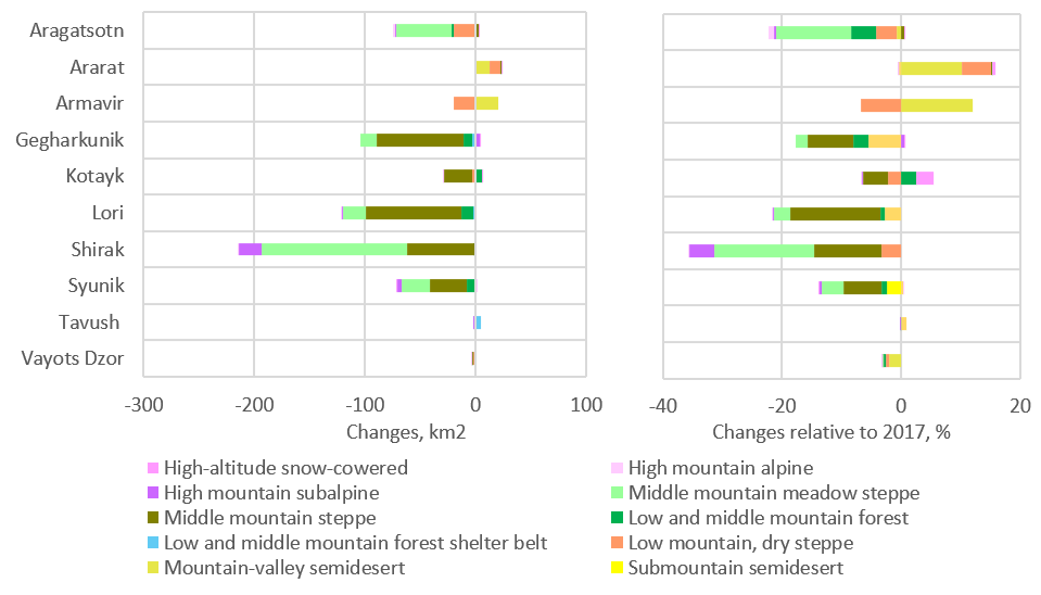
Նկար 7. Բնական լանդշաֆտի տարածքի փոփոխություններ 2017–2023 թվականներին՝ ըստ ESRI տվյալների: ա) ամբողջական փոփոխություններ, կմ²; բ) 2017 թվականի նկատմամբ փոփոխված տարածքի մասնաբաժին, %.
Բնական լանդշաֆտների տարածքի փոփոխություններ 2017-2023 թթ, % համեմատ 2017 թ
| Արագած-ոտն | Արարատ | Արմա-վիր | Գեղարքունիք | Կոտայք | Լոռի | Շիրակ | Սյունիք | Տավուշ | Վայոց ձոր | Ընդամենը | |
| Փոփոխություններ, քմ² | |||||||||||
| Բարձրադիր ձյունածածկ | 0.01 | 0.02 | 0.00 | 0.00 | 0.73 | 0.00 | 0.00 | -0.02 | 0.00 | 0.00 | 0.75 |
| Բարձր լեռնային ալպյան | -1.34 | -0.06 | 0.00 | 0.12 | -0.03 | 0.00 | -0.01 | 0.39 | 0.00 | -0.10 | -1.03 |
| Բարձր լեռնային ենթալպյան | -1.25 | -0.27 | 0.00 | 4.27 | -0.88 | -0.61 | -20.75 | -4.58 | -0.01 | -0.13 | -24.20 |
| Միջին լեռնային մարգագետնային տափաստան | -50.33 | 0.25 | 0.00 | -14.64 | 0.38 | -21.47 | -131.42 | -25.29 | -0.10 | -0.24 | -242.86 |
| Միջին լեռնային տափաստան | 3.15 | 0.60 | 0.00 | -79.17 | -24.57 | -85.90 | -61.12 | -33.06 | 0.00 | -0.45 | -280.52 |
| Ցածր և միջին լեռնային անտառ | -2.17 | 0.01 | 0.00 | -7.23 | 5.60 | -10.54 | 0.00 | -7.54 | -0.74 | -0.41 | -23.03 |
| Ցածր-միջին բարձրության, լեռնային անտառային պաշտպանիչ գոտի | 0.00 | -0.09 | 0.00 | -3.13 | 0.00 | -2.25 | 0.00 | 1.33 | 4.63 | 0.00 | 0.48 |
| Ցածր լեռնային, չոր տափաստանային | -18.98 | 9.98 | -19.59 | 0.00 | -3.44 | 0.00 | -0.66 | 0.00 | 0.00 | -1.19 | -33.88 |
| Լեռնահովտային կիսաանապատ | -0.36 | 13.03 | 20.23 | 0.00 | 0.00 | 0.00 | 0.00 | 0.00 | 0.00 | -0.76 | 32.14 |
| Ենթալեռ կիսաանապատ | 0.00 | 0.00 | 0.00 | 0.00 | 0.00 | 0.00 | 0.00 | -0.37 | 0.00 | 0.00 | -0.37 |
| Փոփոխված տարածքի մասնաբաժինը՝ 2017 թվականի նկատմամբ, % | |||||||||||
| Արագած-ոտն | Արարատ | Արմա-վիր | Գեղարքունիք | Կոտայք | Լոռի | Շիրակ | Սյունիք | Տավուշ | Վայոց ձոր | ||
| Բարձրադիր ձյունածածկ | 0.03 | 0.39 | 0.00 | 0.00 | 2.88 | 0.00 | 0.00 | -0.03 | 0.00 | 0.00 | |
| Բարձր լեռնային ալպյան | -0.91 | -0.09 | 0.00 | 0.03 | -0.02 | 0.00 | 0.00 | 0.06 | 0.00 | -0.04 | |
| Բարձր լեռնային ենթալպյան | -0.32 | -0.11 | 0.00 | 0.48 | -0.30 | -0.15 | -4.15 | -0.45 | -0.01 | -0.03 | |
| Միջին լեռնային մարգագետնային տափաստան | -12.53 | 0.12 | 0.00 | -1.87 | 0.13 | -2.84 | -16.85 | -3.67 | -0.04 | -0.06 | |
| Միջին լեռնային տափաստան | 0.52 | 0.10 | 0.00 | -7.74 | -4.25 | -15.14 | -11.24 | -6.27 | 0.00 | -0.07 | |
| Ցածր և միջին լեռնային անտառ | -4.16 | 0.01 | 0.00 | -2.48 | 2.48 | -0.72 | 0.00 | -0.88 | -0.05 | -0.38 | |
| Ցածր-միջին բարձրության, լեռնային անտառային պաշտպանիչ գոտի | 0.00 | -0.28 | 0.00 | -5.55 | 0.00 | -2.70 | 0.00 | 0.39 | 0.95 | 0.00 | |
| Ցածր լեռնային, չոր տափաստանային | -3.47 | 4.89 | -6.71 | 0.00 | -2.10 | 0.00 | -3.36 | 0.00 | 0.00 | -0.53 | |
| Լեռնահովտային կիսաանապատ | -0.80 | 10.29 | 11.97 | 0.00 | 0.00 | 0.00 | 0.00 | 0.00 | 0.00 | -2.01 | |
| Ենթալեռ կիսաանապատ | 0.00 | 0.00 | 0.00 | 0.00 | 0.00 | 0.00 | 0.00 | -2.43 | 0.00 | 0.00 | |
3. Մարզերի կարևորության գնահատում՝ Արմենիայում բնական լանդշաֆտային բազմազանության պահպանման համար
Հայաստանում բնական լանդշաֆտների պահպանման գործում մարզերի կարևորությունը գնահատելու համար մենք օգտագործեցինք ցուցանիշը՝ յուրաքանչյուր մարզում գտնվող լանդշաֆտային տարածքների ընդհանուր բաժնի հարաբերակցությունը տվյալ լանդշաֆտի ամբողջ տարածքի նկատմամբ։ Այս մոտեցումը կիրառվեց՝ ապահովելու համար, որ հազվագյուտ լանդշաֆտների արժեքը չնվազի։ ESRI-ի և ESA-ի տվյալների հիման վրա կազմված վարկանիշները շատ նման են՝ տարբերվելով միայն ցուցակի միջին հատվածում գտնվող մի քանի մարզերի դիրքերով, որոնք ունեն նման ցուցանիշներ։
Նկար 8. Արցախում բնական լանդշաֆտային բազմազանության պահպանման համար մարզերի կարևորության դասակարգումը։ Մարզերի ընդհանուր տոկոսը կարող է գերազանցել 100%:
Վիճակագրական աղյուսակներ
2017 թվականից մինչև 2023 թվականը մարզերի ամբողջությամբ ընդհանուր արժեքային ցուցանիշը փոխվել է ոչ ավելի, քան 3%-ով (Նկ. 24D-2): Շիրակ մարզի արժեքը նվազել է 52.0%-ից մինչև 48.8%, հիմնականում այնտեղ պահպանվող ազգային խոտածածկ-ստեփային տարածքի մասնաբաժնի նվազման պատճառով: Արարատյան մարզում այս ցուցանիշը բարձրացել է 79.3%-ից մինչև 82.1%՝ անտառային, ստեփային և կիսաանապատային գոտիների մասնաբաժինների աճի շնորհիվ։ Մյուս մարզերում ընդհանուր ցուցանիշի փոփոխությունները փոքր են եղել։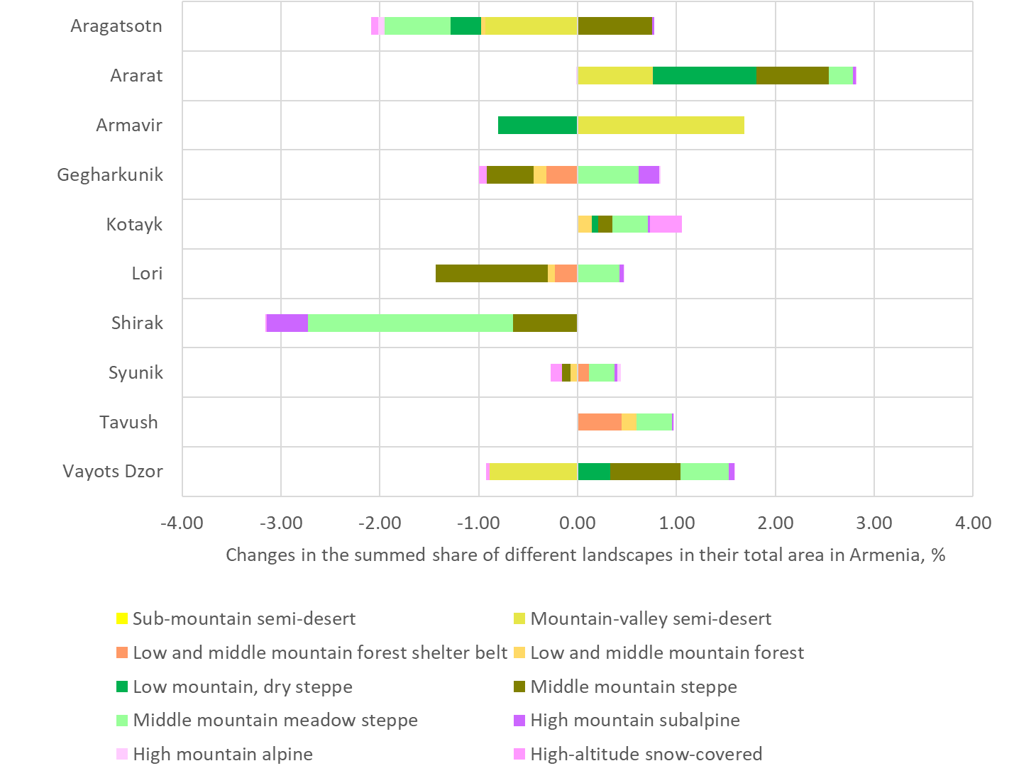
Նկ. 9. Մարզերի կարևորության փոփոխությունները Արևմտյան Հայաստանի բնական լանդշաֆտային բազմազանության պահպանման գործում 2017–2023 թվականներին։