We apologize for possible errors in the machine translation of the site
3.1.E. Carbon storage in soil and tree biomass
GIS analysis – Vardan Asatryan (NAS RA)
Presentation of results – Elena Bukvareva (BCC-Armenia);
The assessment of soil carbon stocks was made using data from the World Soils 250m Organic Carbon Stocks dataset. Carbon stock in tree biomass was estimated using the area of tree cover from ESRI (2023) and the average carbon content of wood. According to the Acopian Center, a pilot study conducted in forests near the town of Vanadzor (northeastern Armenia) revealed a value of 98 tC/ha. However, data from State of the World’s Forests, FAO, 2011 estimate the total carbon stock in living forest biomass in Armenia at 13 million tons, with an average of 48 tC/ha across the country. We used this average in our calculations.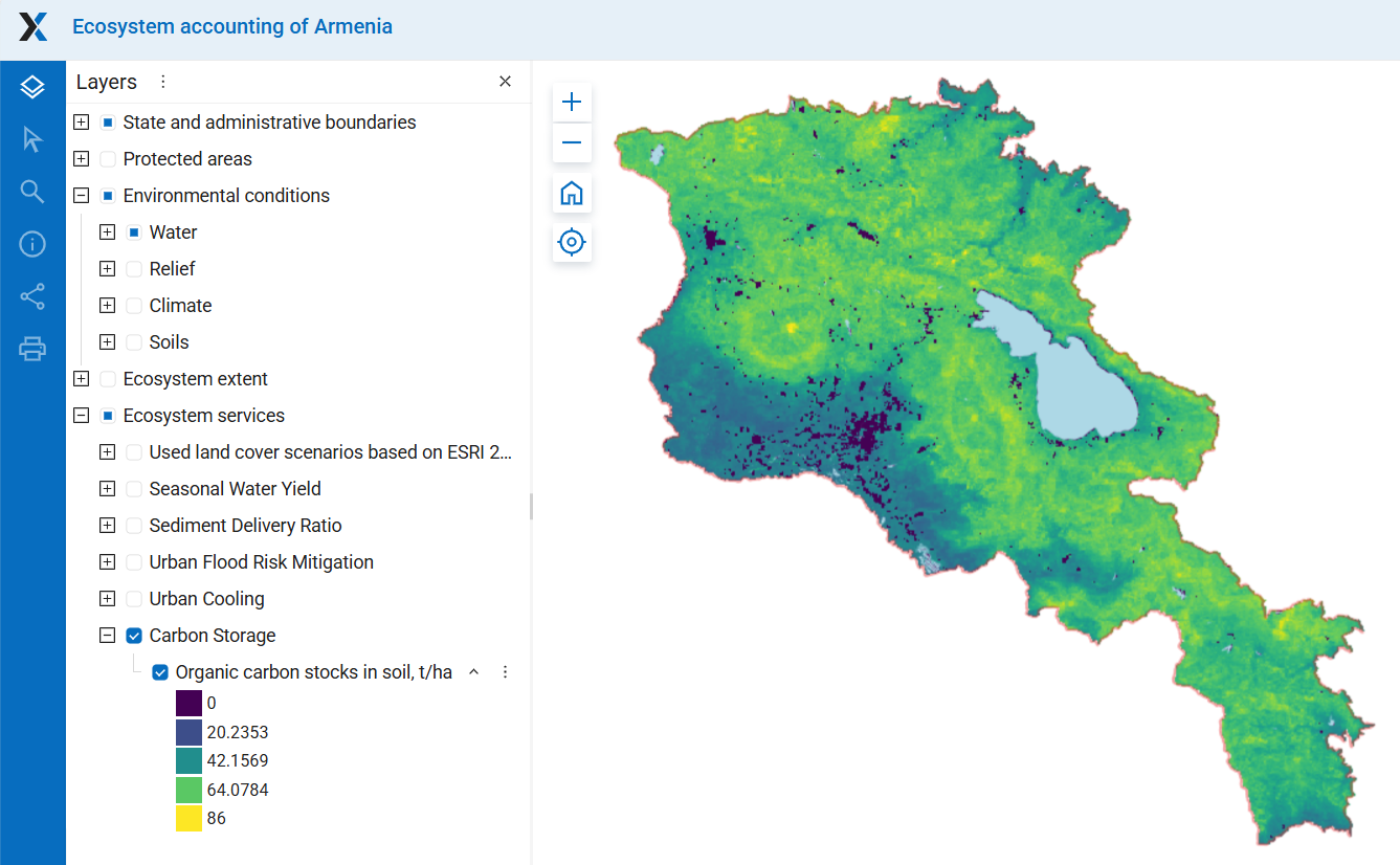
Figure 31E-1. Soil carbon stocks, t/ha; for details see project web-GIS, section Ecosystem Services
Carbon stocks in Armenia, provinces and vegetation zones
The average soil carbon content across provinces ranges from 62 to 32 tС/ha and across vegetation zones (Section 2.3) from 64 to 29 tC/ha. Total carbon stock in 0-30 cm depth soils in Armenia amounts to 158.4 MtC, and in tree biomass 15 MtC (in 2023). The total carbon stock in soils and tree biomass amounts to 173 MtС. Due to the relatively small forest area in Armenia, the main carbon stock (91,4%) is stored in soils.
Carbon content in the 30-cm soil layer in most marzes ranges between 52–61 t/ha. In Armavir and Ararat, it is lower (32 and 44 t/ha, respectively) due to the carbon-poor semi-desert soils (Figure 31E-2 a). The total carbon stock is highest in marzes Syunik, Lori, and Gegharkunik (25-28 MtC), and lowest in marz Armavir (4 MtC) because of low carbon content in soil and small area of ecosystems (Table 31E-1; Figure 31E-2 b). The carbon stock in tree biomass makes a noticeable addition to soil carbon only in marzes Tavush and Lori.
According to the World Soils 250 m Organic Carbon Stocks dataset, soil carbon content is highest in mountain grassland zones (64 t C/ha) and in the forest and steppe zones (57–59 t C/ha). The lowest carbon content is found in desert and semi-desert soils (29–35 t C/ha) (Table 31E-2; Figure 31E). Soil carbon stock is highest in the steppe, forest, and subalpine zones, and lowest in the juniper zone due to its limited extent. Total carbon stock is highest in the forest zone because of the substantial contribution from tree biomass.
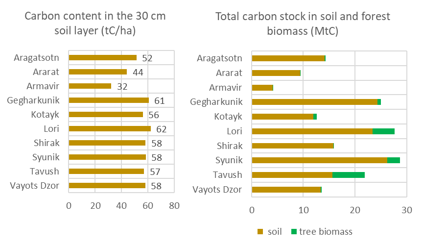
Figure 31E-2. Carbon stocks across marzes: a) Carbon content in the 30-cm soil layer, tС/ha; b) Carbon stock in soil and tree biomass, MtC . Area of the marz Gegharkunik is accounted excluding Lake Sevan
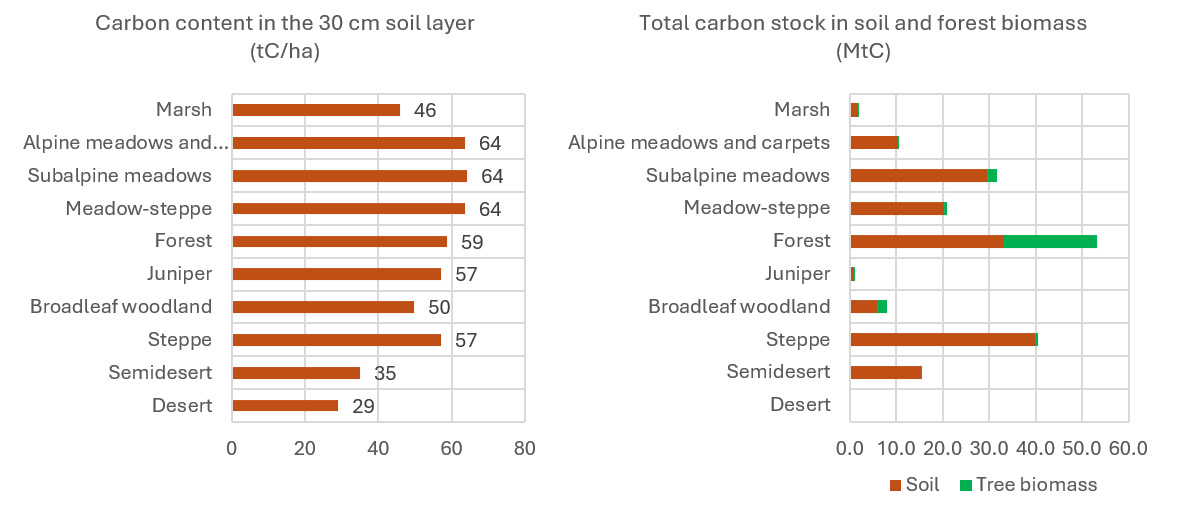
Figure 31E-2. Carbon stocks across vegetation zones: a) Carbon content in the 30-cm soil layer, tС/ha; b) Carbon stock in soil and tree biomass, MtC
Changes in carbon stock in tree biomass from 2017 to 2023
Changes in carbon stock were assessed based on changes in the area of tree cover, using ESRI data. Across marzes, the most significant absolute decline was observed in Syunik, and the most significant relative decline was observed in Armavir marz (Table 31E-1; Figure 31E-3). Across vegetation zones, stocks declined in all zones except the desert (which has no woody vegetation) and broadleaf woodlands. The largest decline occurred in the forest zone; however, compared with 2017, it amounted to only 4% (Table 31E-2; Figure 31E-4). Figure 31E-3. Changes in carbon stock in tree biomass from 2017 to 2023 across marzes: a) Changes in carbon stock, MtC; b) Changes in carbon stock relative to 2017,%
Figure 31E-4. Changes in carbon stock in tree biomass from 2017 to 2023 across vegetation zones: a) Changes in carbon stock, MtC; b) Changes in carbon stock relative to 2017,%
Table 31E-1. Carbon stock in marzes and changes in it from 2017 to 2023
| Province | Mean carbon content in the 30 cm soil layer (tC/ha) | Area (excluding Lake Sevan), ha | Carbon stock in soil, MtC | Area of trees, ESRI 2017, ha | Area of trees, ESRI 2023, ha | Carbon stock in tree biomass, 2017, MtC | Carbon stock in tree biomass, 2023, MtC | Total carbon stock in soil and tree biomass, 2023, MtC | Changes in carbon stock in tree biomass from 2017 to 2023 | |
| MtC | % relative to 2017 | |||||||||
| Aragatsotn | 52 | 273612 | 14.10 | 5254 | 4825 | 0.25 | 0.23 | 14.34 | -0.02 | -8.2 |
| Ararat | 44 | 211491 | 9.37 | 3047 | 2620 | 0.15 | 0.13 | 9.50 | -0.02 | -14.0 |
| Armavir | 32 | 126370 | 4.10 | 284 | 55 | 0.01 | 0.00 | 4.10 | -0.01 | -80.5 |
| Gegharkunik | 61 | 397392 | 24.14 | 13493 | 12956 | 0.65 | 0.62 | 25.01 | -0.03 | -4.0 |
| Kotayk | 56 | 211480 | 11.90 | 17174 | 15310 | 0.82 | 0.73 | 12.63 | -0.09 | -10.9 |
| Lori | 62 | 376300 | 23.41 | 86951 | 88374 | 4.17 | 4.24 | 27.65 | 0.07 | 1.6 |
| Shirak | 58 | 271863 | 15.87 | 1308 | 1343 | 0.06 | 0.06 | 15.93 | 0.00 | 2.6 |
| Syunik | 58 | 449335 | 26.27 | 63426 | 50774 | 3.04 | 2.44 | 28.71 | -0.61 | -19.9 |
| Tavush | 57 | 272624 | 15.60 | 130410 | 131633 | 6.26 | 6.32 | 21.92 | 0.06 | 0.9 |
| Vayots Dzor | 58 | 229654 | 13.36 | 4710 | 3813 | 0.23 | 0.18 | 13.54 | -0.04 | -19.0 |
| All pro-vinces | 56 | 2820122 | 158.11 | 326059 | 311701 | 15.65 | 14.96 | 173.32 | -0.69 | -4.6 |
Table 31E-2. Carbon stock in vegetation zones and changes in it from 2017 to 2023
| Carbon content in the 30 cm soil layer (tC/ha) | Area, ha | Carbon stock in soil, MtC | Area of trees, ESRI 2017, ha | Area of trees, ESRI 2023, ha | Carbon stock in tree biomass, 2017, MtC | Carbon stock in tree biomass, 2023, MtC | Total carbon stock in soil and tree biomass, 2023, MtC | Changes in carbon stock in tree biomass from 2017 to 2023, MtC | Changes in carbon stock in tree biomass from 2017 to 2023, % relative to 2017 | |
| Marsh | 45.9 | 39055 | 1.79 | 246.8 | 146.6 | 0.01 | 0.01 | 0.02 | -0.005 | -40.6 |
| Alpine meadows and carpets | 63.6 | 163794 | 10.42 | 588.6 | 106.4 | 0.03 | 0.01 | 0.03 | -0.023 | -81.9 |
| Subalpine meadows | 64.2 | 460885 | 29.60 | 51282.2 | 43987.0 | 2.46 | 2.11 | 4.57 | -0.350 | -14.2 |
| Meadow-steppe | 63.6 | 318335 | 20.26 | 13415.2 | 13327.4 | 0.64 | 0.64 | 1.28 | -0.004 | -0.7 |
| Forest | 58.7 | 564380 | 33.14 | 432710.2 | 416416.2 | 20.77 | 19.99 | 40.76 | -0.782 | -3.8 |
| Juniper | 57.2 | 13560 | 0.78 | 901.2 | 720.7 | 0.04 | 0.03 | 0.08 | -0.009 | -20.0 |
| Broadleaf woodland | 49.8 | 117317 | 5.84 | 43015.7 | 46096.8 | 2.06 | 2.21 | 4.28 | 0.148 | 7.2 |
| Steppe | 57.1 | 696619 | 39.78 | 18417.5 | 16405.2 | 0.88 | 0.79 | 1.67 | -0.097 | -10.9 |
| Semidesert | 35.0 | 437940 | 15.32 | 1137.1 | 602.9 | 0.05 | 0.03 | 0.08 | -0.026 | -47.0 |
| Desert | 29.1 | 752 | 0.02 | 0.0 | 0.0 | 0 | 0 | 0.00 | 0.000 | 0 |