We apologize for possible errors in the machine translation of the site
Reduction of the potential distribution area of 24 vegetation types identified on the 1961 vegetation map
For this analysis, the vegetation map from the 1961 Atlas of the Armenian SSR* (digitized by Vardan Asatryan) and the ESRI land cover 2023 data were used.
Vegetation map 1961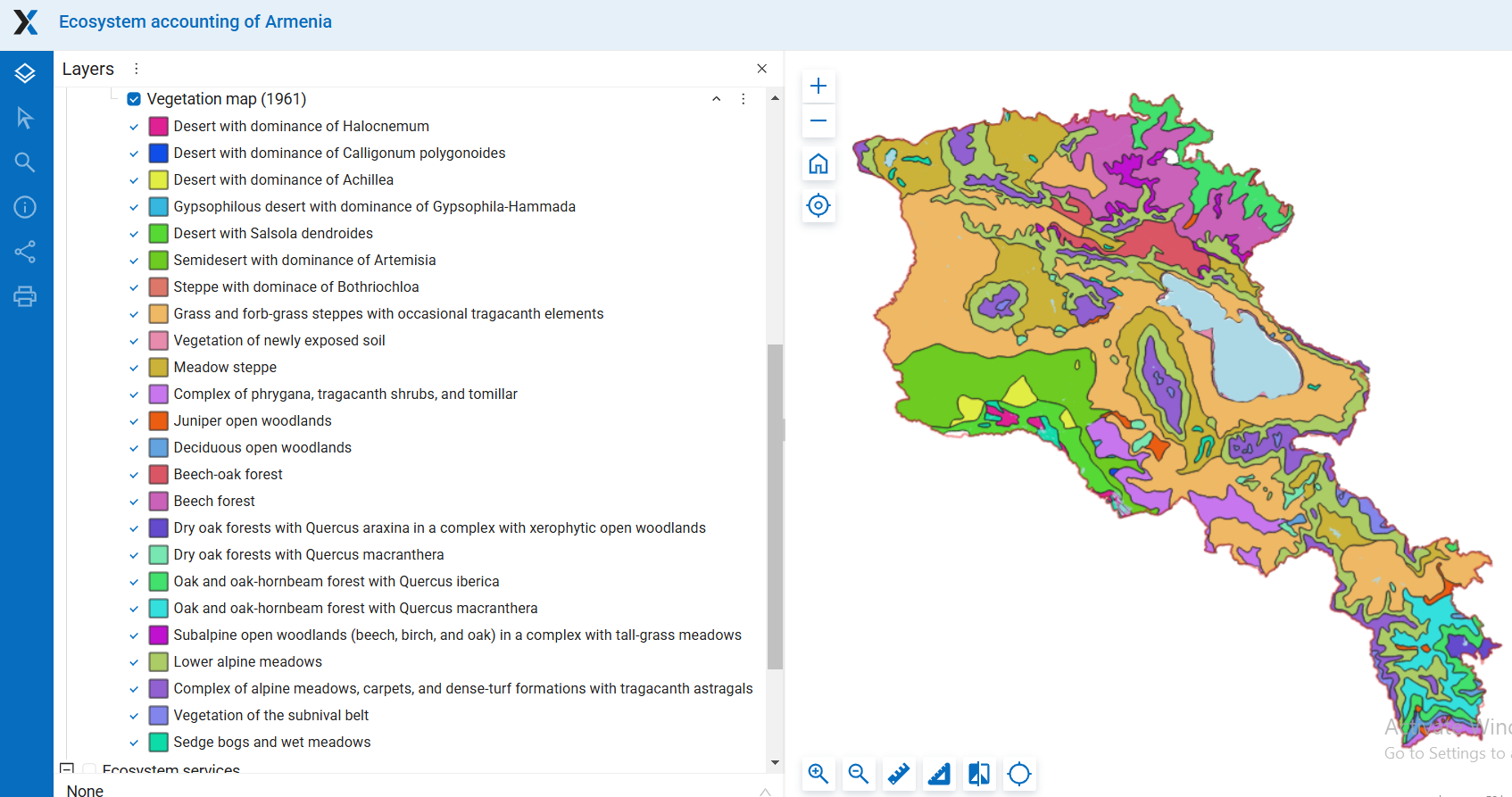
Vegetation map excluding crops and built-up areas from ESRI 2023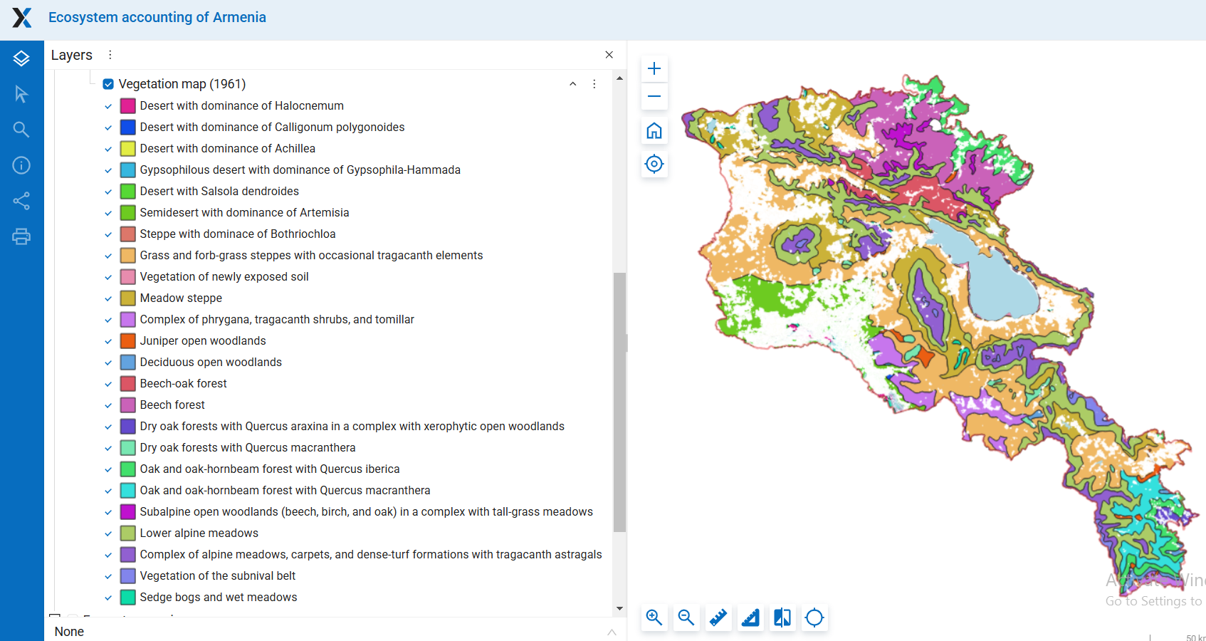
For detailed maps see in the Section Ecosystem Extent/Vegetation
Based on the intersection of the vegetation map with the land cover data, vegetation types have been ranked according to their rarity (area in 2023), and the proportion of their potential area currently occupied has been identified.
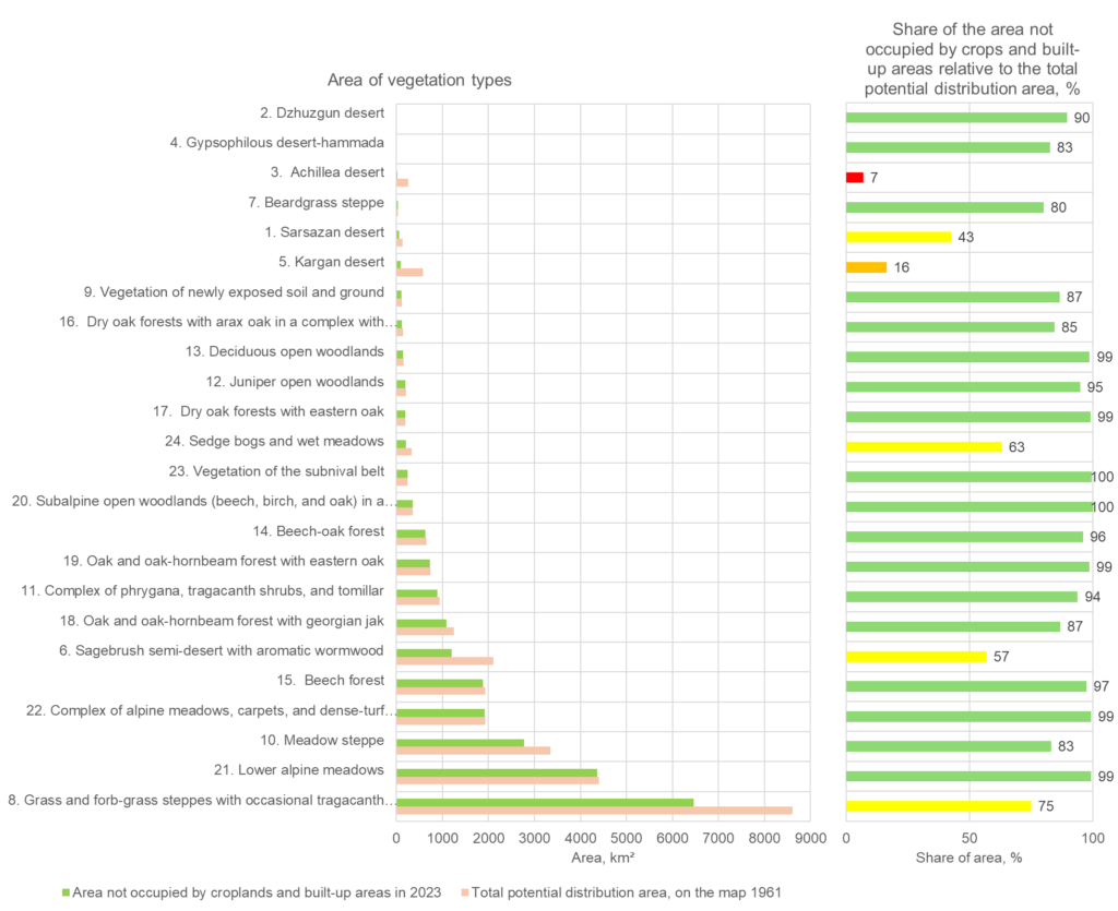
| Total potential distribution area on the map 1961, km2 | Area not occupied by crops and built-up areas in 2023, km2 | Share of the area not occupied by crops and built-up areas relative to the total potential area, % | |
| 1. Sarsazan desert | 135.1 | 57.5 | 42.5 |
| 2. Dzhuzgun desert | 7.4 | 6.6 | 89.6 |
| 3. Achillea desert | 256.0 | 17.6 | 6.9 |
| 4. Gypsophilous desert-hammada | 9.8 | 8.1 | 82.6 |
| 5. Kargan desert | 582.7 | 95.3 | 16.4 |
| 6. Sagebrush semi-desert with aromatic wormwood | 2107.2 | 1201.5 | 57.0 |
| 7. Beardgrass steppe | 39.1 | 31.3 | 80.0 |
| 8. Grass and forb-grass steppes with occasional tragacanth elements | 8614.1 | 6464.9 | 75.1 |
| 9. Vegetation of newly exposed soil and ground | 124.5 | 107.8 | 86.6 |
| 10. Meadow steppe | 3347.4 | 2781.2 | 83.1 |
| 11. Complex of phrygana, tragacanth shrubs, and tomillar | 944.1 | 886.5 | 93.9 |
| 12. Juniper open woodlands | 209.5 | 198.9 | 94.9 |
| 13. Deciduous open woodlands | 153.5 | 151.6 | 98.8 |
| 14. Beech-oak forest | 650.5 | 625.7 | 96.2 |
| 15. Beech forest | 1934.6 | 1884.0 | 97.4 |
| 16. Dry oak forests with arax oak in a complex with xerophytic open woodlands | 143.1 | 121.1 | 84.6 |
| 17. Dry oak forests with eastern oak | 200.9 | 199.1 | 99.1 |
| 18. Oak and oak-hornbeam forest with georgian jak | 1252.1 | 1088.1 | 86.9 |
| 19. Oak and oak-hornbeam forest with eastern oak | 737.8 | 728.2 | 98.7 |
| 20. Subalpine open woodlands (beech, birch, and oak) in a complex with tall-grass meadows | 360.6 | 360.5 | 100.0 |
| 21. Lower alpine meadows | 4398.9 | 4370.6 | 99.4 |
| 22. Complex of alpine meadows, carpets, and dense-turf formations with tragacanth astragals | 1932.9 | 1919.6 | 99.3 |
| 23. Vegetation of the subnival belt | 246.7 | 245.7 | 99.6 |
| 24. Sedge bogs and wet meadows | 327.8 | 207.2 | 63.2 |
* Atlas of the Armenian Soviet Socialist Republic. Ed. Baghdasaryan A.B., Davtyan G.S., Harutyunyan A.B., Martirosyan G.M., Marukhyan A.G., Mkrtchyan S.S., Shakhbazyan M.S., Stepanyan L.A. (chairman), Urusov V.V. Academy of Sciences of the Armenian SSR. Main Directorate of Geodesy and Cartography. Yerevan – Moscow, 1961