2.7. Approaches for the inclusion of Armenia in the Global Ecosystem Atlas
The work was carried out with the participation of:
Aleksanyan Alla (Institute of Botany after A. Takhtajyan NAS RA)
Asatryan Vardan (Scientific center of zoology and hydroecology of NAS RA)
Bukvareva Elena (BCC Armenia)
Fayvush George (Institute of Botany after A. Takhtajyan NAS RA)
Kazakov Eduard (NextGIS OÜ, Estonia)
The Global Ecosystems Atlas (GEA) will be the first comprehensive harmonized open resource on the extent, change, condition and risk of all the world’s ecosystems. The inclusion of Armenia in the GEA is seen by us as an important step to demonstrate the international significance of national ecosystem accounting.
Our approach consists in the integration of a scientific vegetation map with regularly updated land cover data. Scientific map takes into account the ecological and biodiversity features of terrestrial ecosystems that are difficult or impossible to detect from space. Regularly updated land cover data allows for timely monitoring of changes in the extent of natural ecosystems. This approach was tested for extent accounting of natural vegetation types and landscapes.
2.7A. Initial data to start
Data from two required sources were available to us: scientific vegetation maps and global land cover datasets (Figure 2.7A-1).
Armenia has an world-class scientific tradition in botany and geobotany. Over many decades, Armenian scientists have developed a wide range of vegetation maps with varying levels of detail. Based on this long-term academic foundation, the updated vegetation map was developed and recoded to IUCN GET by Alla Aleksanyan and George Fayvush (Institute of Botany after A. Takhtajyan of the National Academy of Sciences of the Republic of Armenia) and digitized by Vardan Asatryan (Scientific center of zoology and hydroecology of NAS RA).
Since Armenia currently lacks a national regularly updated land cover dataset, we tested five land cover datasets available in open access. Three of them — ESRI, ESA, and GLAD datasets — most accurately reflect the current land cover of Armenia and can be used for the zero version of the Armenia ecosystem map for the GEA.
 Figure 2.7a-1. Source data for representing Armenia in the GEA (Open image in new tab to see it larger)
2.7B. Zero version of Armenian ecosystem map for the GEA
The current area of natural terrestrial ecosystems, is defined as the potential area of a given vegetation type minus cropland and built-up areas based on land cover data. The current distribution of forests is also derived from land-cover data (Fig. 2.7B-1).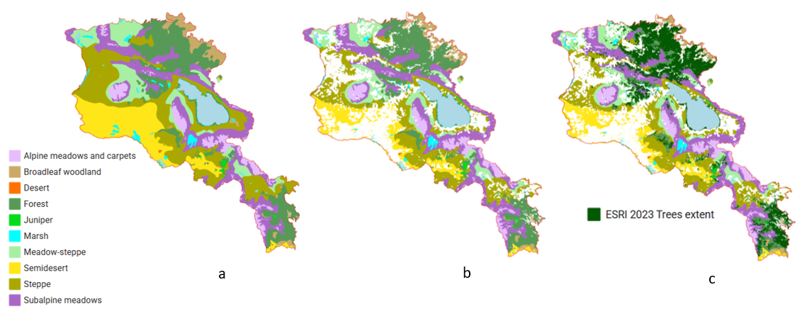 Figure 2.7B-1. Main steps to produce a map of current terrestrial ecosystems using ESRI data as an example: a) potential distribution of vegetation types; b) current natural area of vegetation zones excluding croplands and built-up areas; c) ecosystem types, including current tree cover For detailed map see project Web-GIS, sections Ecosystem Extent/Vegetation/Vegetation map 2025
The vegetation map, originally created as a vector dataset, was rasterized to a spatial resolution of 10 m and was subsequently reclassified into ecosystem types according to the IUCN Global Ecosystem Typology (GET). Next, we used data from two land cover datasets – ESRI 2023 and ESA 2021 – to produce different versions of the zero version map. Four land cover classes were used from the land cover data and reclassified into the IUCN GET. Since the Prototype Ecosystem Accounting for Armenia focuses exclusively on terrestrial ecosystems, aquatic ecosystems were not classified and were defined generally as Water.
| Vegetation map of Armenia | IUCN GET |
| Alpine vegetation | T6.4 Temperate alpine grasslands and shrublands |
| Subalpine meadows | T4.5 Temperate subhumid grasslands |
| Meadow-steppe | T4.5 Temperate subhumid grasslands |
| Steppe | T5.1 Semi-desert steppes |
| Grasslands within forest vegetation zone | T4.5 Temperate subhumid grasslands |
| Juniper woodlands | T4.4 Temperate woodlands |
| Broadleaf woodlands | T4.4 Temperate woodlands |
| Semidesert | T5.1 Semi-desert steppes |
| Desert | T5.1 Semi-desert steppes |
| Land cover data | IUCN GET |
| Trees; Tree cover | T2.2 Deciduous temperate forests |
| Built-up areas | T7.4 Urban and industrial ecosystems |
| Crops; Croplands | T7.1 Annual croplands |
| Water; Permanent water bodies | Water |
As our analysis comparing cropland areas from land cover datasets and ARMSTAT data has shown (TRSection 2.1.B), tested land cover datasets include the following categories of agricultural land in the ‘cropland’ class: annually plowed areas (T7.1 Annual croplands); perennial agricultural plantations, i.e., vineyards and orchards (T7.3 Plantations); some of the fields that have not been plowed this year (T7.5 Derived semi-natural pastures and old fields). At this stage, we do not have the data necessary to separate these three categories within cropland land cover class, therefore, we reclassified it as T7.1 Annual croplands. Land categories such as “T7.2 Sown pastures and fields” and forest plantations aimed at timber production are not typical for Armenia; therefore, we did not consider them. Category “T7.5 Derived semi-natural pastures and old fields” can be found in three vegetation zones: meadow-steppe, steppe, and semidesert. However, at this stage, we do not have the data necessary to identify T7.5 within these zones.
Four land cover classes (trees, crops, built areas, water) from the ESRI 2023 and ESA 2021 land-cover datasets (10 m resolution) were overlaid onto the vegetation raster using a priority-based approach; that is, these classes replaced the underlying vegetation class, while all other pixels retained their original vegetation classification. Thus, two versions of the map with a 10 m resolution were produced based on ESRI and ESA data. Next, ESA- and ESRI-based 10 m categorical rasters were aggregated to a 100 m resolution using a majority (modal) resampling approach. For each 100 m cell, the corresponding block of 10 × 10 underlying 10 m pixels (100 pixels in total) was identified, and the ecosystem class occurring most frequently within that block was assigned to the output cell. NoData values were excluded from the calculation. This approach preserves categorical integrity and avoids artificial class mixing that would result from averaging or interpolative resampling methods. Resulting rasters are ESA_based_100m.tif and ESRI_based_100m.tif (Figure 2.7B-2).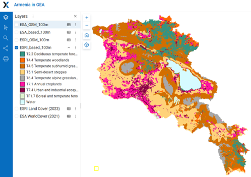
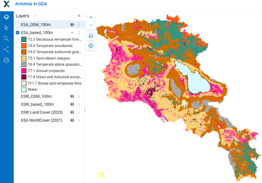 Figure 2.7B-2. Maps of current terrestrial ecosystems of Armenia based on ESRI 2023 and ESA 2021 land cover data. For detailed maps see project Web GIS, section Armenia in GEA
Due to differences in the methodologies used by ESRI and ESA to identify built-up areas, croplands, and tree cover, the resulting maps show noticeable differences in the areas of these classes. The more detailed ESA land-cover dataset identifies grasslands, croplands, and tree cover within settlement areas; therefore, in the raster based on ESA data, built-up area is smaller than in the raster based on ESRI data and some settlements with a high density of trees (small private gardens, street trees, and parks) are identified in the ESA data predominantly as tree cover (Fig. 2.7B-3).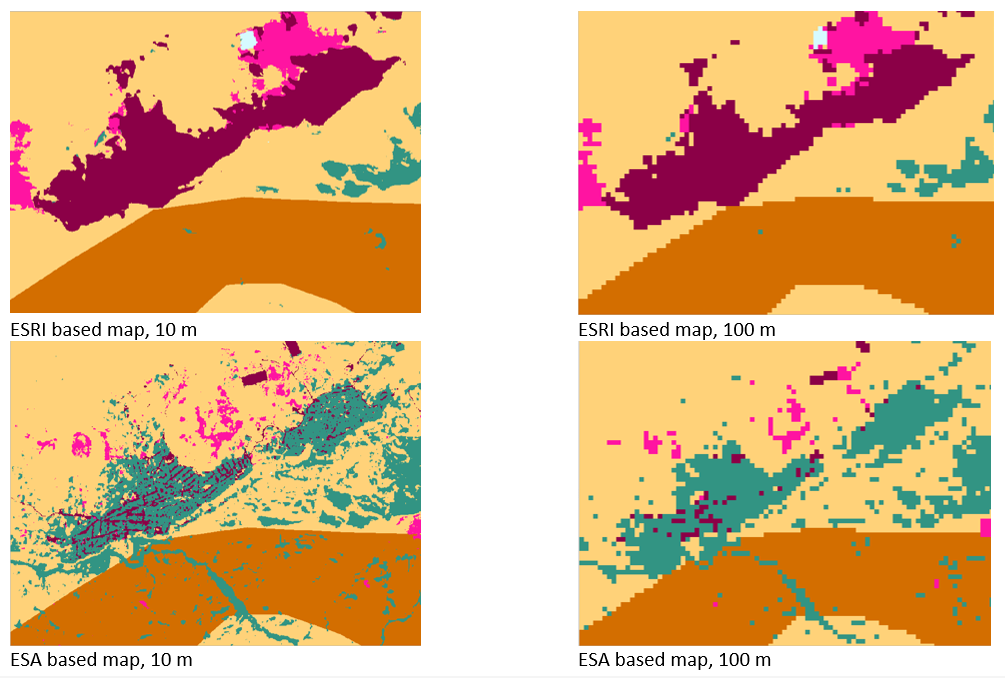 Figure 2.7B-3. The settlement of Garni in the map versions based on ESRI and ESA data.
However, according to the understanding of urban ecosystem types in the IUCN GET, all tree-covered, herbaceous, and vacant land areas located within urban boundaries are considered part of urban ecosystems. Therefore, we considered it appropriate to provide the GEA team with two additional versions of the map, in which all areas within settlement boundaries are assigned to class T7.4 Urban and industrial ecosystems. Settlement areas were delineated using OpenStreetMap data by combining administrative boundaries of towns and the city of Yerevan (Fig. 2.7B-4 a) with built-up area polygons which represent the actually built-up areas of settlements at a lower hierarchical level than towns and city Yerevan ((Fig. 2.7B-4 b). These features were merged into a single settlement layer (Fig. 2.7B-4 c), which was overlaid onto the ESA- and ESRI-based rasters and classified as T7.4 Urban and industrial ecosystems. Resulting rasters are ESA_OSM_100m.tif and ESRI_OSM_100m.tif (Figure 2.7B-5).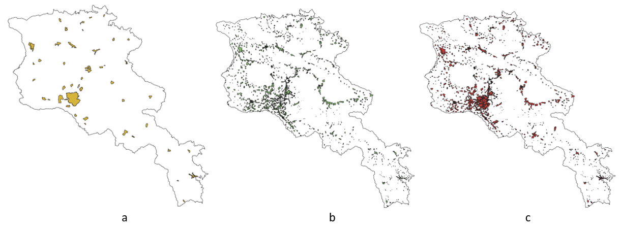 Figure 2.7B-4. Used OSM layers: (a) administrative boundaries of towns and the city of Yerevan; (b) built-up area polygons; (c) combined layer.
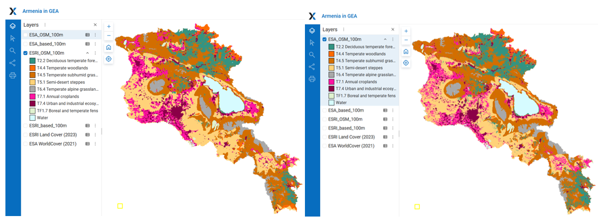 Figure 2.7B-5. Maps of current terrestrial ecosystems of Armenia based on ESRI 2023 and ESA 2021 land cover data and built-up areas from OSM. For detailed maps see project Web GIS, section Armenia in GEA
2.7C. Comparison of Zero version maps for the GEA with Government-reported data
To compare the created ecosystem maps with land-cover class area data provided by the Government of Armenia (TR Section 2.2A), all non-forest ecosystem classes in our maps were aggregated into a single class. We used government-reported data for 2022 (https://www.arlis.am/hy/acts/171671). All versions of created maps show cropland areas that are smaller than those reported in the official government statistics, while the area of non-forest ecosystems is larger. This indicates that part of croplands included in government statistics is identified as grassland by the land-cover datasets. Built-up area in maps created for the GEA exceeds the values reported in government statistics, except for the map version based on ESA data, where the built-up area is substantially smaller. With respect to forest area, the map versions based on ESA data show better agreement with the government statistics (Figure 2.7C-1). The sum of the absolute differences between class areas in the cerated maps and the government statistics is smallest for the map based on ESA and OSM data – ESA_OSM_100m.tif (Figure 2.7C-2). 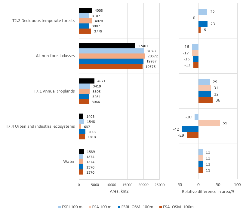 Figure 2.7C-1. Area of main land cover classes in ecosystem maps created for GEA and in government-reported data (a) and relative differences in area between GEA maps and government statistics, % of government-reported area (b)
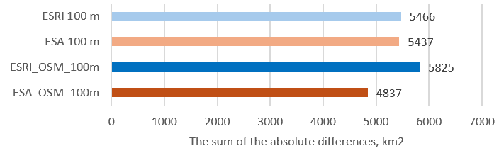
Figure 2.7C-2. The sum of the absolute differences between maps for GEA and government statistics
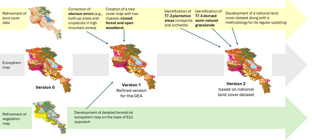
2.7D. Subsequent versions of the map
As shown by our analysis (TR Section 2.1), all global land cover datasets contain significant errors, and therefore, the ecosystem map of Armenia and the ecosystem accounting should eventually be based on a corrected national land cover dataset.
Currently, we are at the stage of the Zero version of the map, which can be created based on the Prototype ecosystem accounting V1 and available global land cover datasets. Moving forward, two main stages of improvement for this map can be foreseen. Along this path, improvements are needed both in the vegetation map and in the land cover data.
Version 1 may be based on a detailed map of Armenian ecosystems developed using the ELU approach (TR Section 4.2C) as well as certain refinements of land cover data:
– Corrections of obvious errors in land cover data (e.g., built-up areas and croplands in high mountain zones);
– Creation of tree cover map with two classes – closed forest and open woodlands
Version 2 should be based on an accurate national land cover dataset including
– Refinement of T7.1 Annual cropland areas;
– Identification of T7.3 Plantation areas (vineyards and orchards)
– Identification of T7.5 Derived semi-natural grasslands, which requires analysis of satellite imagery and agricultural statistics not only for the current period but also for previous years.