We apologize for possible errors in the machine translation of the site
2.4. Extent of natural landscapes
GIS modeling and analysis – Eduard Kazakov (NextGIS OÜ, Estonia)
Analysis and presentation of results – Elena Bukvareva (BCC-Armenia)
1. Extent of natural landscapes in Armenia
To estimate extent of natural landscapes, the map of landscape zones published in the Fifth National Report of Armenia to the CBD (2014) was used (available in digital form in Forest Atlas of Armenia FAA), along with ESRI land cover data for 2017 and 2023 as well as ESA 2021 data for comparison.
The area of natural landscapes was calculated as the area of a given landscape zone minus waterbodies and anthropogenically transformed territories, that is, built-up areas and croplands.
Landscape zones 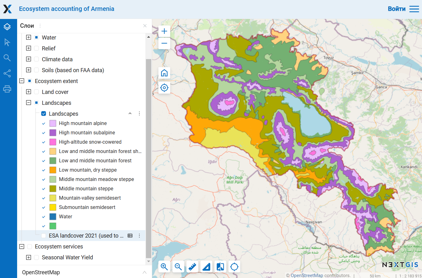
Land cover ESA 2021 Land cover ESRI 2023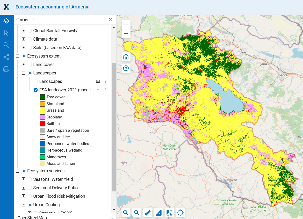
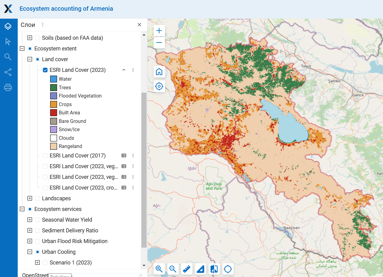 Figure1. The maps used for estimation of the extent of natural landscapes For detailed maps see section “Ecosystem extent”
According to ESRI data, the most human-transformed zone is mountain-valley semi-desert, where only 27% of natural landscapes remain. It is followed by low mountain dry steppe and the middle mountain steppe zones, with 65% and 71% of natural landscapes remaining, respectively. High-mountain snow-covered, alpine, and subalpine zones have been almost unaffected by human activity. Forests are most widespread in zones of low-middle mountain forest (38%) and low-middle mountain forest shelter belt (17%). There is almost no forests in the half of landscape zones – high-altitude snow-cowered, alpine, dry steppe, and semi-deserts (Figure 2; Tables).
ESA data show a generally similar picture, but with smaller built-up area and larger area of tree cover and bare ground, which is particularly noticeable in the semi-deserts, dry steppe, and forest shelter belt (Figure 2; Tables). One of the reasons for this is that, as mentioned above, ESA identifies trees within settlements. The presence of trees in submountain semidesert zone in the ESA data is entirely due to this factor – all trees there are located inside settlements (see Section 2.1.A). In the semi-desert zone, some areas classified by ESRI as croplands were identified by ESA as bare ground and grasslands. As a result, the degree of transformation of this zone is considerably lower in ESA data than in ESRI data.
 Figure2. Share of land cover classes within landscape zones
Figure 3. Share of area of natural land cover classes within landscape zones (%) according ESRI and ESA data
Table 1. Area of land cover classes within landscape zones according to ESRI 2023 data, km2
| Trees | Rangeland | Bare Ground | Snow/ Ice | Water/ Flooded veg. | Crops | Built Area | Total | |
| High-altitude snow-cowered | 0.06 | 183.27 | 3.83 | 7.09 | 0.32 | 1.01 | 0.00 | 195.58 |
| High mountain alpine | 9.90 | 1948.68 | 5.67 | 4.45 | 1.83 | 3.72 | 1.38 | 1975.62 |
| High mountain subalpine | 125.93 | 4222.75 | 3.73 | 0.00 | 2.73 | 49.13 | 10.25 | 4414.52 |
| Middle mountain meadow steppe | 294.31 | 4057.45 | 4.27 | 0.00 | 27.14 | 460.92 | 78.35 | 4922.44 |
| Middle mountain steppe | 108.88 | 4723.60 | 2.97 | 0.00 | 20.69 | 1454.46 | 484.65 | 6795.24 |
| Low mountain, dry steppe | 3.21 | 1461.86 | 3.35 | 0.00 | 5.61 | 454.76 | 329.90 | 2258.69 |
| Low-middle mountain forest | 2361.03 | 2261.51 | 2.81 | 0.00 | 50.26 | 133.77 | 180.49 | 4989.87 |
| Low-middle mount. forest shelter belt | 195.79 | 796.09 | 3.87 | 0.00 | 6.34 | 95.20 | 84.08 | 1181.37 |
| Mountain-valley semidesert | 0.52 | 411.32 | 5.75 | 0.00 | 144.50 | 766.06 | 376.07 | 1704.21 |
| Submountain semidesert | 0.00 | 14.93 | 0.03 | 0.00 | 0.20 | 0.19 | 1.97 | 17.33 |
| Sevan | 0 | 0 | 0 | 0 | 1227 | 0 | 0 | 1227.00 |
Table 2. Area of land cover classes within landscape zones according to ESA 2021 data, km2
| Tree cover | Grassland | Shrub-land | Moss/ lichen | Bare/ sparse veg. | Snow/ ice | Water/ wetlands | Cropland | Built-up | Total | |
| High-altitude snow-cowered | 0.01 | 189.85 | 0.00 | 8.91 | 34.14 | 0.44 | 1.37 | 0.00 | 0.00 | 234.72 |
| High mountain alpine | 22.95 | 1814.63 | 0.00 | 25.59 | 106.82 | 0.11 | 2.24 | 5.78 | 0.11 | 1978.24 |
| High mountain subalpine | 189.42 | 4066.87 | 0.00 | 6.11 | 45.19 | 0.01 | 1.87 | 78.13 | 3.13 | 4390.74 |
| Middle mountain meadow steppe | 391.79 | 4088.71 | 0.00 | 0.92 | 21.20 | 0.00 | 28.58 | 404.81 | 22.02 | 4958.03 |
| Middle mountain steppe | 283.17 | 4578.27 | 0.18 | 0.00 | 69.91 | 0.00 | 23.36 | 1688.78 | 191.46 | 6835.12 |
| Low mountain, dry steppe | 90.96 | 1549.08 | 0.00 | 0.00 | 165.79 | 0.00 | 5.12 | 289.93 | 167.83 | 2268.72 |
| Low-middle mountain forest | 2751.63 | 2034.38 | 2.97 | 0.00 | 10.54 | 0.00 | 3.74 | 122.38 | 62.19 | 4987.84 |
| Low-middle mount. forest shelter belt | 327.59 | 695.87 | 6.82 | 0.00 | 14.03 | 0.00 | 5.26 | 103.17 | 31.54 | 1184.29 |
| Mountain-valley semidesert | 36.26 | 458.47 | 0.00 | 0.00 | 160.83 | 0.00 | 39.78 | 706.90 | 206.75 | 1608.98 |
| Submountain semidesert | 1.78 | 13.08 | 0.00 | 0.00 | 1.09 | 0.00 | 0.16 | 0.03 | 0.94 | 17.08 |
| Sevan | 0.00 | 0.00 | 0.00 | 0.00 | 0.00 | 0.00 | 1279.24 | 0.00 | 0.00 | 1279.24 |
The extent of natural areas within landscape zones differs significantly from the total extent of those zones (Figure 4). When comparing the total area of the landscape zones, middle mountain steppes far exceed all other landscape zones. However, if anthropogenic areas are excluded, four types of natural landscapes have similar extents, each covering 15–16% of Armenia’s territory – middle mountain steppe and meadow steppe, subalpine and forest zones. Mountain-valley semi-desert zone is shrinking the most – from 5.4% to 1.4-2.3% – as it has been transformed by human activity to the greatest extent. Differences in the estimated extent of natural landscapes between ESRI and ESA are greatest for the zones most heavily transformed by human activity, as ESA identifies smaller areas of croplands and built-up land (see above).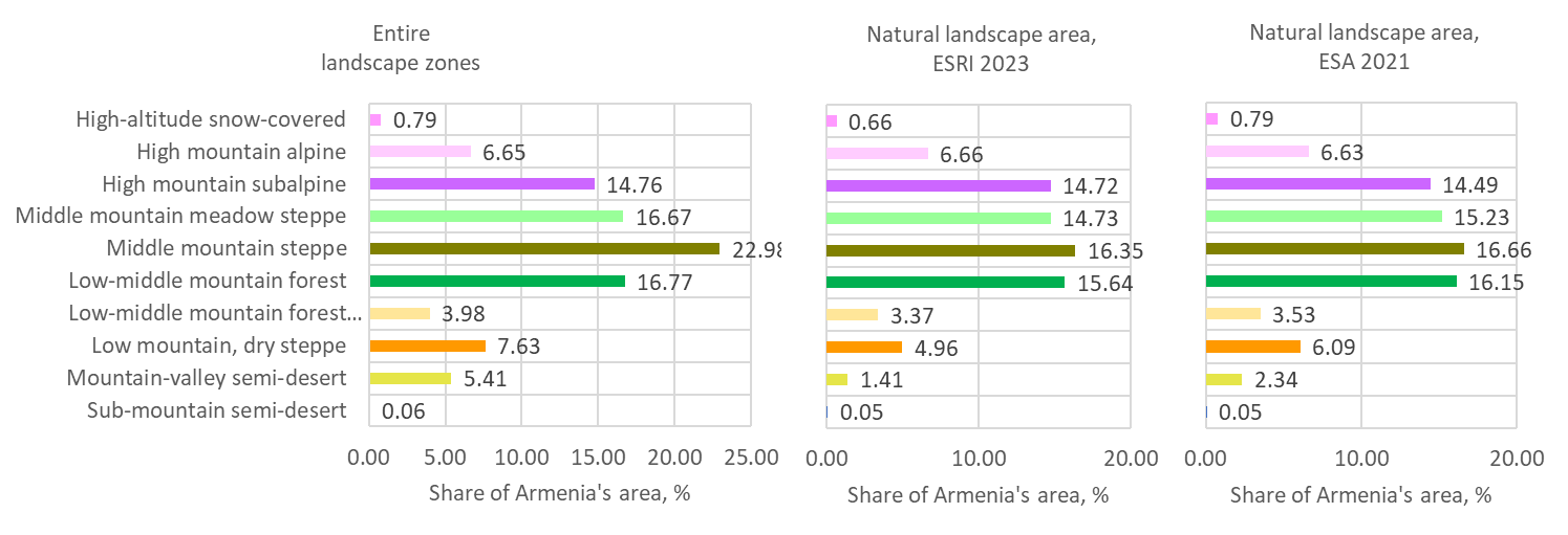
Figure 4. The share of landscape zones and natural landscapes in Armenia’s total area, %
2. Changes in landscape extent from 2017 to 2023 according to ESRI data
The extent of most natural landscapes decreased from 2017 to 2023 due to the expansion of human-occupied areas (croplands and built-up zones), as described in the Section “Extent of land cover classes“. A noticeable increase in natural area was observed only in mountain-valley semi-desert. However, it is important to keep in mind that the restoration of natural communities requires a long period of time.  Figure 5. Absolute and relative changes in natural landscape extent
3. Marz level
In terms of the extent of natural landscapes in marzes, ESRI and ESA provide a very similar picture. The main part of the forest landscape zone is located in three marzes — Lori, Tavush, and Syunik. The largest areas of alpine and subalpine landscapes are found in Syunik and Gegharkunik, although these landscapes are also notably present in all other marzes except Armavir and Tavush. Steppe landscapes are present in all marzes, but in Tavush and Armavir marzes, their area is small. The remaining natural areas of mountain-valley semi-desert are mainly located in the marzes of Ararat and Armavir. Submountain semi-desert is represented by small patches only in the south of Syunik marz.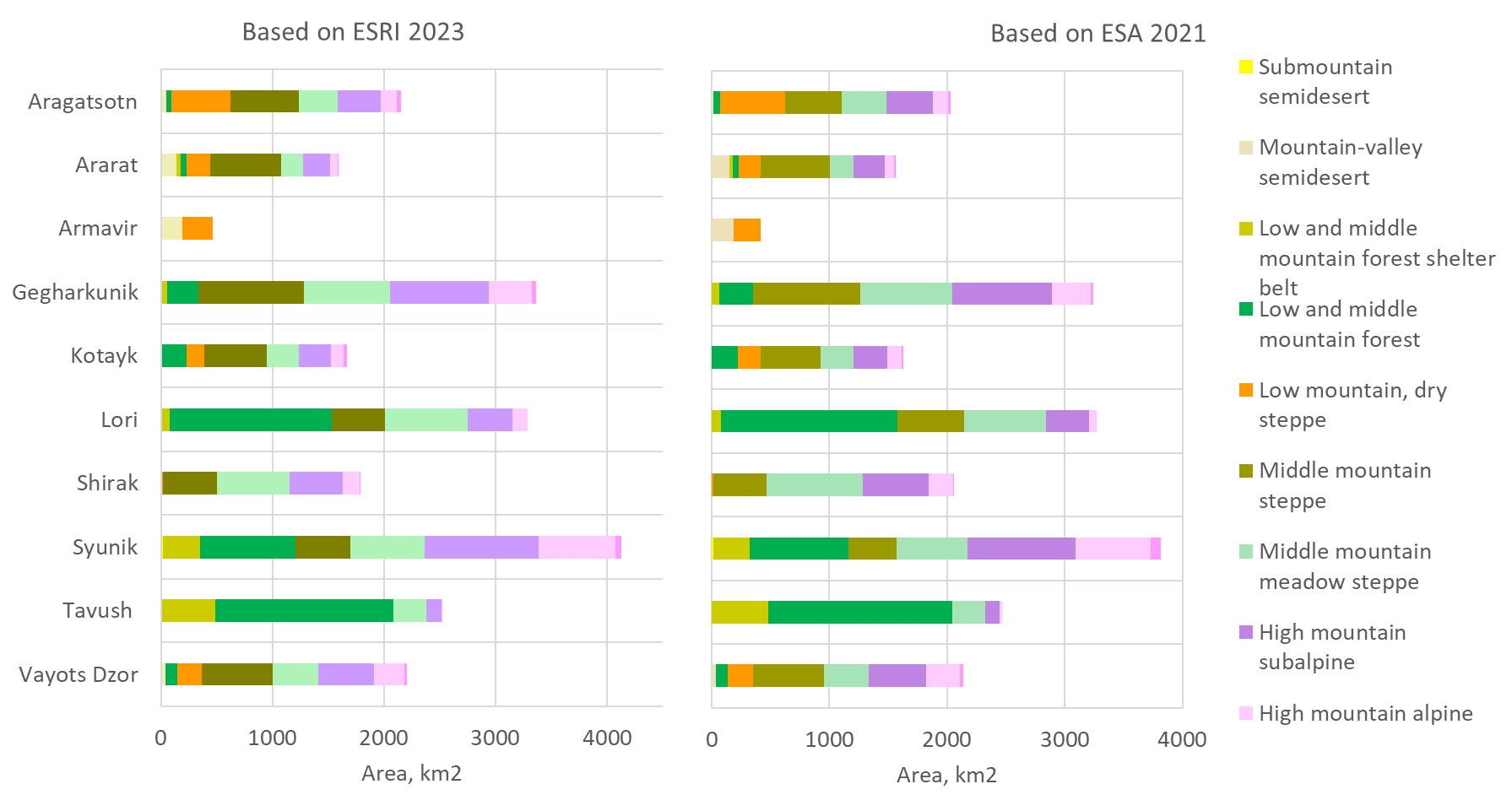
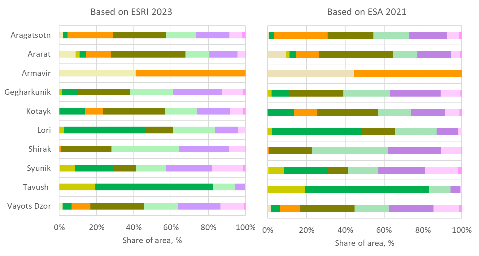 Figure 6. Area and share of natural landscapes in marzes
Table 3. Area of natural landscapes, km2, based on ESRI 2023 land cover data
| Landscape zone | Aragats-otn | Ararat | Armavir | Geghar-kunik | Kotayk | Lori | Shirak | Syunik | Tavush | Vayots Dzor | Armenia |
| High-altitude snow-cowered | 39.1 | 5.9 | 0.0 | 40.2 | 26.2 | 0.0 | 7.5 | 54.5 | 0.0 | 20.9 | 194.2 |
| High mountain alpine | 146.4 | 62.6 | 0.0 | 380.5 | 114.8 | 134.5 | 152.9 | 688.8 | 10.2 | 278.0 | 1968.7 |
| High mountain subalpine | 383.5 | 245.1 | 0.0 | 892.1 | 290.0 | 407.7 | 479.4 | 1021.6 | 134.1 | 499.5 | 4352.8 |
| Middle mountain meadow steppe | 351.3 | 199.8 | 0.0 | 768.9 | 288.0 | 735.7 | 648.7 | 664.7 | 294.6 | 404.3 | 4356.1 |
| Middle mountain steppe | 611.2 | 631.7 | 0.0 | 943.5 | 553.7 | 481.4 | 482.9 | 494.4 | 0.0 | 636.7 | 4835.5 |
| Low mountain, dry steppe | 527.8 | 214.3 | 272.5 | 0.0 | 160.4 | 0.0 | 19.0 | 0.0 | 0.0 | 224.1 | 1418.2 |
| Low/middle mountain forest | 50.1 | 55.7 | 0.0 | 284.5 | 231.3 | 1448.1 | 0.0 | 854.0 | 1595.4 | 106.3 | 4625.4 |
| Low/mid. Mount. forest shelter belt | 0.0 | 33.7 | 0.0 | 53.3 | 0.0 | 81.3 | 0.0 | 338.2 | 489.3 | 0.0 | 995.8 |
| Mountain-valley semidesert | 45.1 | 139.6 | 189.3 | 0.0 | 0.0 | 0.0 | 0.0 | 0.0 | 0.0 | 37.0 | 411.1 |
| Submountain semidesert | 0.0 | 0.0 | 0.0 | 0.0 | 0.0 | 0.0 | 0.0 | 15.0 | 0.0 | 0.0 | 15.0 |
Table 4. Area of natural landscapes, km2, based on ESA 2021 land cover data
| Landscape zone | Aragats-otn | Ararat | Arma-vir | Geghar-kunik | Kotayk | Lori | Shirak | Syunik | Tavush | Vayots Dzor | Armenia |
| High-altitude snow-cowered | 25.6 | 13.7 | 0.0 | 24.8 | 19.2 | 0.0 | 5.1 | 81.2 | 0.0 | 29.6 | 199.2 |
| High mountain alpine | 128.2 | 72.6 | 0.0 | 331.2 | 119.1 | 63.1 | 212.4 | 639.3 | 16.7 | 282.8 | 1865.4 |
| High mountain subalpine | 393.5 | 271.4 | 0.0 | 842.9 | 287.5 | 361.7 | 561.3 | 919.2 | 127.2 | 489.4 | 4254.1 |
| Middle mountain meadow steppe | 378.0 | 195.1 | 0.0 | 778.4 | 279.1 | 699.1 | 811.6 | 601.3 | 274.1 | 376.5 | 4393.0 |
| Middle mountain steppe | 478.6 | 591.4 | 0.0 | 915.3 | 506.6 | 562.9 | 457.4 | 411.9 | 0.2 | 604.4 | 4528.6 |
| Low mountain, dry steppe | 555.8 | 184.8 | 232.9 | 0.0 | 195.7 | 0.0 | 11.2 | 0.0 | 0.0 | 213.2 | 1393.7 |
| Low/middle mountain forest | 59.0 | 54.8 | 0.0 | 286.9 | 222.7 | 1502.0 | 0.0 | 836.1 | 1567.9 | 102.7 | 4631.9 |
| Low/mid. mount. forest shelter belt | 0.0 | 28.6 | 0.0 | 63.3 | 0.0 | 77.6 | 0.0 | 309.6 | 479.1 | 0.0 | 958.2 |
| Mountain-valley semidesert | 11.6 | 147.5 | 186.3 | 0.0 | 0.0 | 0.0 | 0.0 | 0.0 | 0.0 | 36.1 | 381.5 |
| Sub-mountain semidesert | 0.0 | 0.0 | 0.0 | 0.0 | 0.0 | 0.0 | 0.0 | 14.4 | 0.0 | 0.0 | 14.4 |
According to the ESRI land-cover data, the natural area of steppe and meadow-steppe landscapes decreased in all marzes except Vayots Dzor, Tavush, and Ararat (these landscape zones are absent in Armavir); subalpine landscape decreased in Shirak mars; low-mountain dry steppe – in Aragatsotn and Armavir marzes (Figure 24C-2). The only noticeable increases in the natural (non-cropland, non-built-up) area of landscape zones are the increase in mountain-valley semidesert area in the Ararat and Armavir marzes and in area of low mountain, dry steppe in Ararat, driven by a reduction in cropland in these marzes (see Section 2.2.B).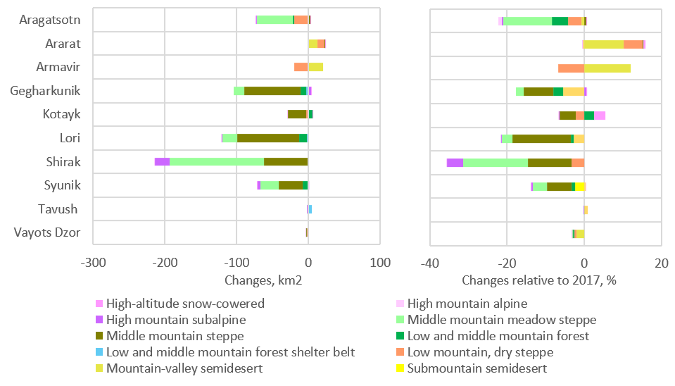
Figure 7. Changes in natural landscape extent from 2017 to 2023, based on ESRI data: a) absolute changes, km2; b) share of changed area relative to 2017, %.
Changes in the area of natural landscapes from 2017 to 2023, % relative to 2017
| Aragats-otn | Ararat | Arma-vir | Geghar-kunik | Kotayk | Lori | Shirak | Syunik | Tavush | Vayots Dzor | Total | |
| Changes, km2 | |||||||||||
| High-altitude snow-cowered | 0.01 | 0.02 | 0.00 | 0.00 | 0.73 | 0.00 | 0.00 | -0.02 | 0.00 | 0.00 | 0.75 |
| High mountain alpine | -1.34 | -0.06 | 0.00 | 0.12 | -0.03 | 0.00 | -0.01 | 0.39 | 0.00 | -0.10 | -1.03 |
| High mountain subalpine | -1.25 | -0.27 | 0.00 | 4.27 | -0.88 | -0.61 | -20.75 | -4.58 | -0.01 | -0.13 | -24.20 |
| Middle mountain meadow steppe | -50.33 | 0.25 | 0.00 | -14.64 | 0.38 | -21.47 | -131.42 | -25.29 | -0.10 | -0.24 | -242.86 |
| Middle mountain steppe | 3.15 | 0.60 | 0.00 | -79.17 | -24.57 | -85.90 | -61.12 | -33.06 | 0.00 | -0.45 | -280.52 |
| Low and middle mountain forest | -2.17 | 0.01 | 0.00 | -7.23 | 5.60 | -10.54 | 0.00 | -7.54 | -0.74 | -0.41 | -23.03 |
| Low-mid. mount. forest shelter belt | 0.00 | -0.09 | 0.00 | -3.13 | 0.00 | -2.25 | 0.00 | 1.33 | 4.63 | 0.00 | 0.48 |
| Low mountain, dry steppe | -18.98 | 9.98 | -19.59 | 0.00 | -3.44 | 0.00 | -0.66 | 0.00 | 0.00 | -1.19 | -33.88 |
| Mountain-valley semidesert | -0.36 | 13.03 | 20.23 | 0.00 | 0.00 | 0.00 | 0.00 | 0.00 | 0.00 | -0.76 | 32.14 |
| Submountain semidesert | 0.00 | 0.00 | 0.00 | 0.00 | 0.00 | 0.00 | 0.00 | -0.37 | 0.00 | 0.00 | -0.37 |
| Share of changed area, relative to 2017, % | |||||||||||
| Aragats-otn | Ararat | Arma-vir | Geghar-kunik | Kotayk | Lori | Shirak | Syunik | Tavush | Vayots Dzor | ||
| High-altitude snow-cowered | 0.03 | 0.39 | 0.00 | 0.00 | 2.88 | 0.00 | 0.00 | -0.03 | 0.00 | 0.00 | |
| High mountain alpine | -0.91 | -0.09 | 0.00 | 0.03 | -0.02 | 0.00 | 0.00 | 0.06 | 0.00 | -0.04 | |
| High mountain subalpine | -0.32 | -0.11 | 0.00 | 0.48 | -0.30 | -0.15 | -4.15 | -0.45 | -0.01 | -0.03 | |
| Middle mountain meadow steppe | -12.53 | 0.12 | 0.00 | -1.87 | 0.13 | -2.84 | -16.85 | -3.67 | -0.04 | -0.06 | |
| Middle mountain steppe | 0.52 | 0.10 | 0.00 | -7.74 | -4.25 | -15.14 | -11.24 | -6.27 | 0.00 | -0.07 | |
| Low and middle mountain forest | -4.16 | 0.01 | 0.00 | -2.48 | 2.48 | -0.72 | 0.00 | -0.88 | -0.05 | -0.38 | |
| Low-mid. mount. forest shelter belt | 0.00 | -0.28 | 0.00 | -5.55 | 0.00 | -2.70 | 0.00 | 0.39 | 0.95 | 0.00 | |
| Low mountain, dry steppe | -3.47 | 4.89 | -6.71 | 0.00 | -2.10 | 0.00 | -3.36 | 0.00 | 0.00 | -0.53 | |
| Mountain-valley semidesert | -0.80 | 10.29 | 11.97 | 0.00 | 0.00 | 0.00 | 0.00 | 0.00 | 0.00 | -2.01 | |
| Submountain semidesert | 0.00 | 0.00 | 0.00 | 0.00 | 0.00 | 0.00 | 0.00 | -2.43 | 0.00 | 0.00 | |
3. Assessment of marz importance for conservation of natural landscape diversity in Armenia
To assess the importance of provinces for conserving natural landscapes in Armenia, we used the indicator of the total share of landscape areas located within each province relative to the total area of that landscape in Armenia. This approach was applied to ensure that the value of rare landscapes is not diminished. The rankings based on ESRI and ESA data are very similar, differing only in the positions of some provinces with similar indicators in the middle of the list.
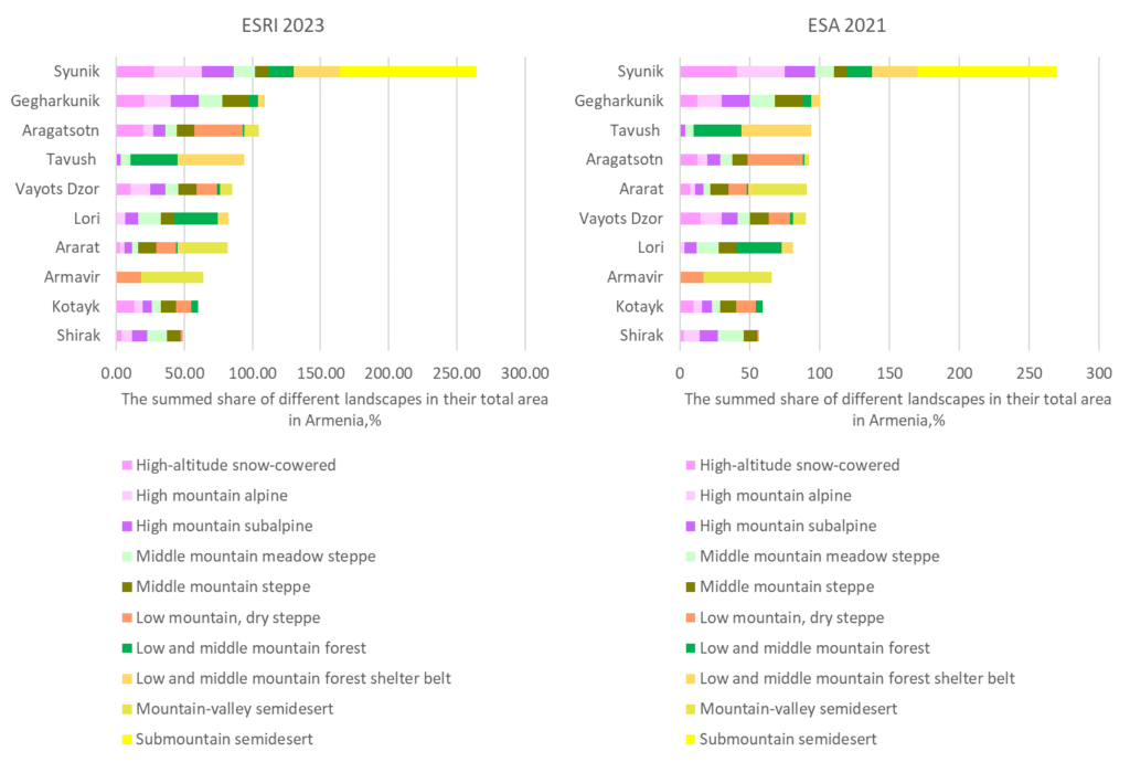
Figure 8. The rankings of marz importance for conservation of natural landscape diversity in Armenia. The total percentage for provinces can exceed 100%.
Statistical tables
From 2017 to 2023, summed value indicator changed by no more than 3% across marzes (Figure 24D-2). The value for Shirak marz declined from 52.0% to 48.8%, primarily due to a decrease in the share of the national meadow-steppe extent conserved there. For Ararat marz, this indicator rose from 79.3% to 82.1% owing to increases in the shares of the forest, steppe, and semidesert zones. For the other marzes, changes in the aggregate indicator were smaller.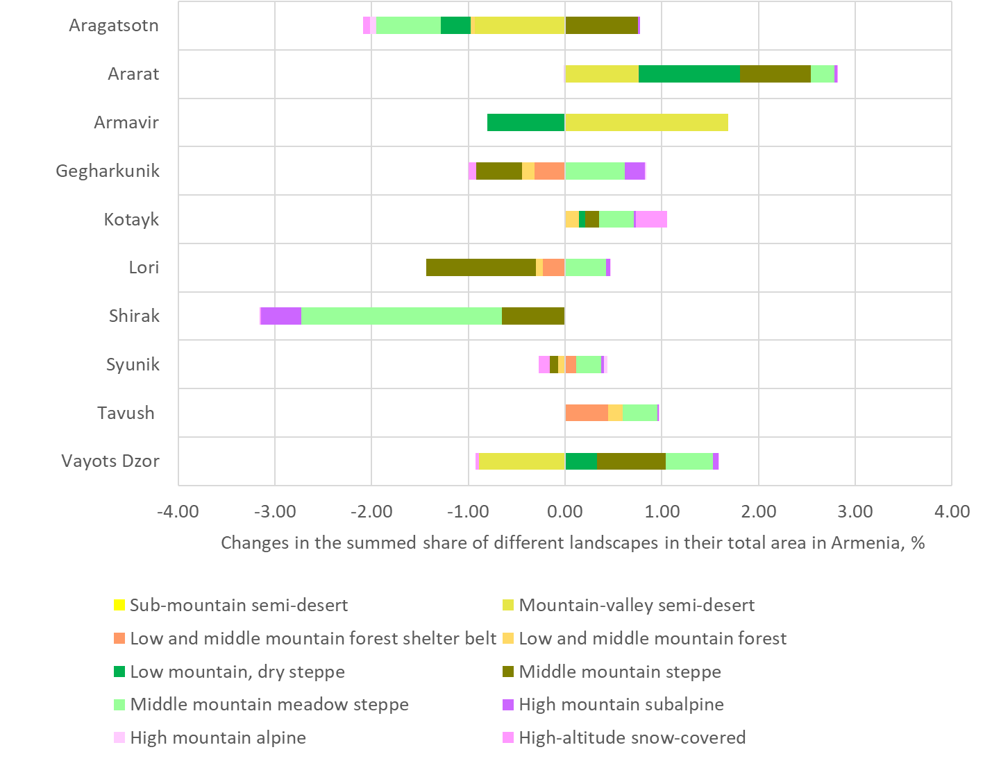
Figure 9. Changes in marz importance for conservation of natural landscape diversity in Armenia from 2017 to 2023.