We apologize for possible errors in the machine translation of the site
Project contribution to Global Biodiversity Framework
The project ‘Ecosystem Accounting in Armenia: Setting the Scene’ (2024-2026) aims to create a Prototype of national ecosystem accounting in Armenia in accordance with the EA-SEEA recommendations, including Stock Accounting (ecosystems) and Flow Accounting (ecosystem services). It makes a direct contribution to GBF (https://www.gbf-indicators.org/) Target 21 aimed at providing informational support for the conservation and sustainable use of biodiversity, which, in turn, contributes to the Targets 1 and 11 and Goals A and B for the conservation and sustainable use of biodiversity and the maintenance of ecosystem services.
The main inputs are as follows:
– The contribution to Target 21 and indicator 21.1 (Indicator on biodiversity information for monitoring the global biodiversity framework) is a prototype of non-monetary ecosystem accounting for terrestrial ecosystems and ecosystem services, serving as informational support for achieving GBF targets and goals.
– The contribution to Target 1 and indicators A1 (Red list of ecosystems) and A2 (Extent of natural ecosystems): a prototype of ecosystem extent accounting, including data on the area of natural ecosystems and landscapes, its changes from 2017 to 2023, and examples of ecosystem rarity ranking and mapping.
– The contribution to Target 11 and indicators B.1 and 11.1 (Services provided by ecosystems): a prototype of ecosystem service accounting, including estimates and maps of supplied ES, their changes from 2017 to 2023, and ES supply-demand balances.
The project results indirectly contribute to other GBF indicators and targets providing an informational basis for management and educational efforts aimed to conservation and sustainable use of biodiversity.

Contribution to Target 21
(Target 21. Ensure that the best available data, information and knowledge are accessible to decision makers, practitioners and the public to guide effective and equitable governance, integrated and participatory management of biodiversity, and to strengthen communication, awareness-raising, education, monitoring, research and knowledge management and, also in this context, traditional knowledge, innovations, practices and technologies of indigenous peoples and local communities should only be accessed with their free, prior and informed consent, in accordance with national legislation)
Indicator 21.1 Indicator on biodiversity information for monitoring the global biodiversity framework
The overall outcome of the project will be the creation of a Prototype for a national ecosystem accounting for terrestrial ecosystems in non-monetary indicators for Armenia. The Prototype includes maps, national and provincial indicators, as well as estimates of changes from 2017 to 2023 for Ecosystem Extent and Ecosystem Services. At this stage we did not consider the issue of Ecosystem Condition due to the lack of open data.
The EA Prototype and the team of Armenian experts participating in the project will ensure the following important steps to achieve Target 21:
– to formulate main requirements for the scientific, technical, and organizational support of national ecosystem accounting and pass them on to the responsible authorities in Armenia.
– to raise awareness of government agencies, the scientific community and the public about the importance of Armenia’s ecosystems for the well-being of the population and the economy as well the necessity of ecosystem accounting.
The Prototype of Ecosystem Extent account contributes to achieving Target 1, and The Prototype of Ecosystem Service account contributes to achieving Target 11 (examples see below)
Prototype of Ecosystem Extent account
For assessing the current ecosystem extent and its changes in recent years, we used ESRI 2017 and 2023 land cover data. In the future, data from other land cover sources may be used.
Prototype of Ecosystem Extent account includes five sections of ecosystem extent indicators:
1. Extent of natural land cover classes →
2. Extent of landscape zones and natural landscapes →
3. Extent of landscape – landcover classes (LLCC) that can be seen as ecosystem proxies →
4. Extent of vegetation types based on a vegetation map updated by the project’s experts (in progress)
5. Anthropogenic transformation of the potential distribution area of 24 vegetation types identified on the map from the Atlas of the Armenian SSR, 1961 (in progress)
These sections contain the following estimates:
– Extent in Armenia and in provinces of Armenia (marzes) (sections 1-4)
– The degree of anthropogenic transformation (sections 2, 4, 5)
– Rarity rankings by the criterion of total area (all sections)
– Provincial importance for conservation of ecosystem diversity (sections 2-4)
– Changes in extent from 2017 to 2023 (sections 1-4)
– Changes in provincial importance for conservation of ecosystem diversity (sections 2-4)
Prototype of Ecosystem Service account
Prototype of Ecosystem Service account will include the following sections
Seasonal runoff regulation (InVEST Seasonal Water Yield) →
Prevention of soil water erosion and ensuring runoff quality (InVEST Sediment Delivery Ratio) →
Flood risk mitigation (InVEST Urban Flood Risk Mitigation) →
Сooling effect of terrestrial ecosystems (InVEST Urban Cooling) →
Carbon storage in terrestrial ecosystems (soil and living wood) (in progress)
Non-timber production (medicinal, culinary, and honey-bearing species (in progress)
Production of livestock feed on natural pastures and hayfields (in progress)
Pollination (in progress)
Natural conditions for outdoor recreation (in progress)
All sections contain the following data:
– Maps of ES indicators
– ES statistics in Armenia and in provinces of Armenia (marzes)
– Supply-demand balance (for all ESs except 3-5)
– Changes in ES indicators from 2017 to 2023
Contribution to Target 1
(Target 1. Ensure that all areas are under participatory, integrated and biodiversity inclusive spatial planning and/or effective management processes addressing land- and sea-use change, to bring the loss of areas of high biodiversity importance, including ecosystems of high ecological integrity, close to zero by 2030, while respecting the rights of indigenous peoples and local communities)
Indicator A.1 Red List of Ecosystems
The approach we used, based on the intersection of maps of landscape zones and vegetation with land cover data, allows us to assess the actual area of terrestrial natural ecosystems, rank them by rarity using the area criterion, and create an ecosystem rarity map (Fig.1).
However, this approach is suitable for ranking the most common, less common, and relatively rare ecosystems, but it is not suitable for the identification and assessment of the rarest ecosystem types, as they are not represented on classic academic landscape and vegetation maps. Additionally, the rarest LLSS types, such as wooded areas in high-mountain or semi-desert zones, may either be land cover errors or anthropogenic formations. Identifying and accounting for the rarest ecosystems require specialized work based on field surveys.
Nevertheless, even at this stage, we have demonstrated how the contribution of individual provinces to the conservation of Armenia’s ecosystem diversity can be assessed, as well as how it changed due to LULC changes (Fig.2).
Examples for landscape-land cover classes (LLCCs) as terrestrial ecosystem proxies
(for details see here)

Figure1. Ranking LLCCs by their area (woody LLCCs are indicated as W, non-woody as N-W)
and the map of LLCC rarity (white color in the map corresponds to crops and built-up areas)

Figure2. The ranking of provincial importance for conserving ecosystem diversity in Armenia (on left) and changes in provincial importance from 2017 to 2023, % relative to 2017 (on right)
Indicator A.2 Extent of natural ecosystems
The current area of natural ecosystems and landscapes has been determined for Armenia as a whole, as well as for provinces and the largest watersheds (Fig. 3). Changes in ecosystem and landscape area from 2017 to 2023 have been identified (Fig.4). These examples illustrate how ecosystem extent accounting could be organized in the future national ecosystem accounting system, which will serve as an informational basis for managing this indicator.
Examples for landscape-land cover classes (LLCCs) as terrestrial ecosystem proxies
(for details see here)
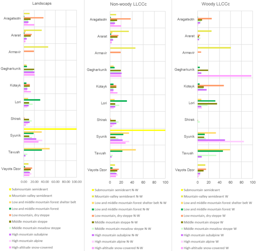
Figure 3. The share of the area of natural landscapes and LLCCs within provinces relative to their total area in Armenia, %

Figure 4. Changes in LLCC extent in Armenia from 2017 to 2023, % relative to 2017
Indicator 11.1 Services provided by ecosystems
The data from the Ecosystem Service accounting prototype, even at its unfinished stage, highlight issues important for biodiversity conservation and management:
1) the key importance of terrestrial ecosystems for the well-being of the population and the economy of Armenia.
2) The weakening of ecosystem services (although minor in most cases in Armenia) as a result of the reduction in the area of natural ecosystems.
Terrestrial ecosystems retaining the water that falls as precipitation provide more than 90% of the baseflow (streamflow with watershed residence times of months to years). For a hypothetical scenario where natural vegetation (grasslands and forests) is replaced by bare soil, baseflow is minimal, as the majority of water quickly flow into streams and water bodies (Fig.5, 6). This means that terrestrial ecosystems provide runoff in summer—the driest and hottest period of the year—which is critically important for Armenia (see here).
Terrestrial ecosystems significantly reduce flood risk in May and June, when Armenia receives the highest amount of precipitation, increasing runoff retention by 9% – 13% compared to bare soil in different watersheds and reducing quick runoff by 17% to 49% (Fig. 7) (see here).
Natural terrestrial vegetation prevents more than 90% of erosion and more than 95% of sediment export (Fig. 8, 9) (see here).
Supply-demand analysis on the base of ARMSTAT water consumption statistics identifies provinces and watersheds with runoff and baseflow surplus or deficit (Fig. 10, see here). As for the ES of prevention of soil erosion and sediment export to streams, the need for it is almost fully met, with the average share of avoided sediment export per m3 of water use exceeding 95% in all provinces and watersheds (see here).
ES changes from 2017 to 2023 indicate their weakening in provinces and watersheds where grasslands and forests have been replaced by crops and built-up areas (see an example in Fig.11).
Actual landcover 2023, B, mm (mean B=51.3) Bare ground, B, mm (mean B= 3.4)

Figure 5. Baseflow with current land cover and under bare ground scenario where natural ecosystems (grasslands and forests) were replaced by bare soil

Figure 6. The share of baseflow in total runoff with current land cover and under bare ground scenario

Figure 7. ES of flood risk mitigation: increase in runoff retention and decrease in quick runoff provided by natural ecosystems, % relative to the total values of indicators
Erosion on bare ground, tons/pixel/year Actual erosion in 2023, tons/pixel/year

Figure 8. Erosion with current land cover and under bare ground scenario where natural ecosystems (grasslands and forests) were replaced by bare soil
Figure 9. Current and avoided erosion and sediment export into streams in provinces of Armenia
Figure 10. Supply-demand balance for the ES of seasonal runoff regulating

Figure 11. Changes in baseflow and quick flow in provinces and watersheds of Armenia from 2017 to 2023, % relative to 2017